فائل:DC neighborhoods map.png

اس نمائش کا حجم: 526 × 599 پکسلز۔ دیگر تصمیمات: 211 × 240 پکسلز | 421 × 480 پکسلز | 674 × 768 پکسلز | 899 × 1,024 پکسلز | 1,493 × 1,700 پکسلز۔
اصل فائل (1,493 × 1,700 پکسل، فائل کا حجم: 1.52 MB، MIME قسم: image/png)
خلاصہ
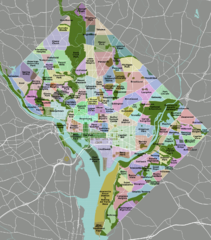
| تفصیل | DC neighborhoods map |
| تاریخ | |
| ماخذ | self-made, tracing done from PD satellite imagery |
| مصنف | Peter Fitzgerald |
| اجازت (فائل کا دوبارہ استعمال) |
CC-by 3.0 |
| دوسرے نسخے | SVG available on Wikitravel Shared, although it is not the current version, as Shared has a 8MB filesize limit... |
|
Need a higher resolution version? There's one available at File:DC neighborhoods map high res.png. (The thumbnail does not display images at such a high resolution—to access the file, click the "Full resolution" link [1] below the broken thumbnail.) |
![[1]](https://upload.wikimedia.org/wikipedia/commons/b/b8/DC_neighborhoods_map_high_res.png)
اجازہ کاری
میں اس تخلیقی کام کے حقوق کا مالک ہوں اور اسے مندرجہ ذیل اجازت نامے کے تحت شائع کرتا ہوں:
This file is licensed under the Creative Commons Attribution 3.0 Unported license.
- آپ آزاد ہیں:
- شیئر کرنے – کام کو نقل، تقسیم یا منتقل کرنے کے لیے
- ریمکس کے لیے – کام منبطق کرنے کے لیے
- مندرجہ ذیل شرائط کے تحت:
- انتساب – آپ کو اس کام کا انتساب مصنف یا اجازت دہندہ کے بتائے گئے طریقہ کے مطابق دینا ہوگا (تاہم یہ انتساب اس طرح نہیں ہونا چاہیے کہ اسے دیکھ کر ایسا محسوس ہو کہ اصل مصنف یا اجازت دہندہ آپ کے یا آپ کے ذریعہ اس کام کے استعمال کرنے کے حامی ہیں)۔

|
This locator map image could be re-created using vector graphics as an SVG file. This has several advantages; see Commons:Media for cleanup for more information. If an SVG form of this image is available, please upload it and afterwards replace this template with
{{vector version available|new image name}}.
It is recommended to name the SVG file “DC neighborhoods map.svg”—then the template Vector version available (or Vva) does not need the new image name parameter. |
فائل کا تاریخچہ
کسی خاص وقت یا تاریخ میں یہ فائل کیسی نظر آتی تھی، اسے دیکھنے کے لیے اس وقت/تاریخ پر کلک کریں۔
| تاریخ/وقت | تھمب نیل | ابعاد | صارف | تبصرہ | |
|---|---|---|---|---|---|
| رائج الوقت | 02:21، 2 ستمبر 2011ء | | 1,493 × 1,700 (1.52 MB) | Peterfitzgerald | minor change |
| 02:15، 2 ستمبر 2011ء |  | 1,493 × 1,700 (1.52 MB) | Peterfitzgerald | Lots of corrections and refinements | |
| 20:53، 4 جنوری 2010ء |  | 1,493 × 1,700 (1.5 MB) | Peterfitzgerald | split off Kalorama Triangle from Adams Morgan, adjusted Fairlawn & Randall Heights boundaries, & split off Spring Valley from American University Park | |
| 21:45، 30 جنوری 2009ء |  | 1,493 × 1,700 (1.53 MB) | Peterfitzgerald | too high res, it would seem | |
| 21:39، 30 جنوری 2009ء |  | 4,390 × 5,000 (5.66 MB) | Peterfitzgerald | increase resolution | |
| 14:32، 4 ستمبر 2008ء |  | 1,493 × 1,700 (1.53 MB) | Peterfitzgerald | increase font size for better in-article readability | |
| 02:33، 21 اپریل 2008ء |  | 1,493 × 1,700 (1.43 MB) | Peterfitzgerald | a few fixes | |
| 17:10، 14 اپریل 2008ء |  | 1,493 × 1,700 (1.46 MB) | Peterfitzgerald | Separate Burleith from Georgetown | |
| 02:37، 23 فروری 2008ء |  | 1,493 × 1,700 (1.41 MB) | Peterfitzgerald | {{Information |Description=DC neighborhoods map |Source=self-made, tracing done from PD satellite imagery |Date=22 February 2008 |Author= Peter Fitzgerald |Permission=CC-by-SA 3.0 |other_versions=SVG available on [http://wikitrave |
روابط
درج ذیل صفحہ اس فائل کو استعمال کر رہا ہے:
فائل کا عالمی استعمال
مندرجہ ذیل ویکیوں میں یہ فائل زیر استعمال ہے:
- de.wikipedia.org پر استعمال
- en.wikipedia.org پر استعمال
- en.wikivoyage.org پر استعمال
- et.wikipedia.org پر استعمال
- frr.wikipedia.org پر استعمال
- vi.wikipedia.org پر استعمال