فائل:Detailed map of Benson, Arizona.png
اس سے زیادہ ریزولیوشن دستیاب نہیں۔
Detailed_map_of_Benson,_Arizona.png (575 × 425 پکسل، فائل کا حجم: 24 کلوبائٹ، MIME قسم: image/png)

|
This city map image could be re-created using vector graphics as an SVG file. This has several advantages; see Commons:Media for cleanup for more information. If an SVG form of this image is available, please upload it and afterwards replace this template with
{{vector version available|new image name}}.
It is recommended to name the SVG file “Detailed map of Benson, Arizona.svg”—then the template Vector version available (or Vva) does not need the new image name parameter. |
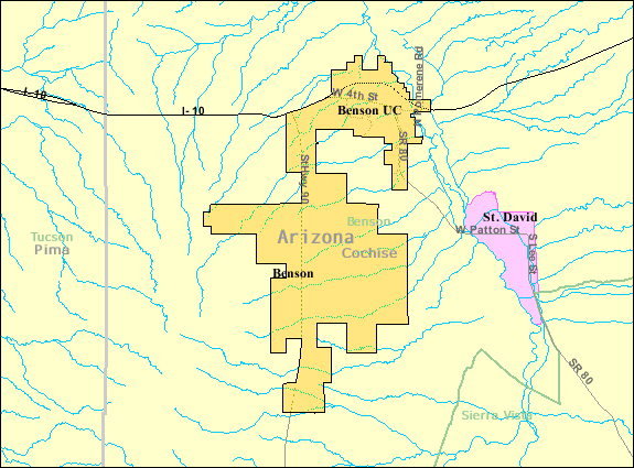
| تفصیل | Map of Benson, a city in Cochise County, Arizona, United States, with its boundaries at the time of the 2000 census. | |||
| تاریخ | نامعلوم تاریخ; downloaded by me on 13 December 2008 | |||
| ماخذ | http://factfinder.census.gov/leg2/46/120825446.gif, from http://factfinder.census.gov | |||
| مصنف | United States Census Bureau | |||
| اجازت (فائل کا دوبارہ استعمال) |
|

فائل کا تاریخچہ
کسی خاص وقت یا تاریخ میں یہ فائل کیسی نظر آتی تھی، اسے دیکھنے کے لیے اس وقت/تاریخ پر کلک کریں۔
| تاریخ/وقت | تھمب نیل | ابعاد | صارف | تبصرہ | |
|---|---|---|---|---|---|
| رائج الوقت | 01:57، 14 دسمبر 2008ء | | 575 × 425 (24 کلوبائٹ) | Nyttend | {{Information |Description=Map of {{w|Benson, Arizona|Benson}}, a city in {{w|Cochise County, Arizona|Cochise County}}, {{w|Arizona}}, {{w|United States}}, with its boundaries at the time of the {{w|2000 United States Census|2000 census}}. |Source=http:// |
روابط
درج ذیل صفحہ اس فائل کو استعمال کر رہا ہے:
فائل کا عالمی استعمال
مندرجہ ذیل ویکیوں میں یہ فائل زیر استعمال ہے:
- ar.wikipedia.org پر استعمال
- arz.wikipedia.org پر استعمال
- azb.wikipedia.org پر استعمال
- ca.wikipedia.org پر استعمال
- ceb.wikipedia.org پر استعمال
- en.wikipedia.org پر استعمال
- eu.wikipedia.org پر استعمال
- fa.wikipedia.org پر استعمال
- fr.wikipedia.org پر استعمال
- sr.wikipedia.org پر استعمال
- sv.wikipedia.org پر استعمال
- tt.wikipedia.org پر استعمال
- www.wikidata.org پر استعمال
- zh-min-nan.wikipedia.org پر استعمال
- zh.wikipedia.org پر استعمال