فائل:Eritrean Railway - 2008-11-04-edit1.jpg

اس نمائش کا حجم: 800 × 600 پکسلز۔ دیگر تصمیمات: 320 × 240 پکسلز | 640 × 480 پکسلز | 1,024 × 768 پکسلز | 1,280 × 960 پکسلز | 2,400 × 1,800 پکسلز۔
اصل فائل (2,400 × 1,800 پکسل، فائل کا حجم: 1.86 MB، MIME قسم: image/jpeg)
خلاصہ
| فوٹوگرافر |
Original photograph taken by User:Voice of Clam, edited by jjron - adjusted levels, reduced highlights, sharpened. |
| تفصیل |
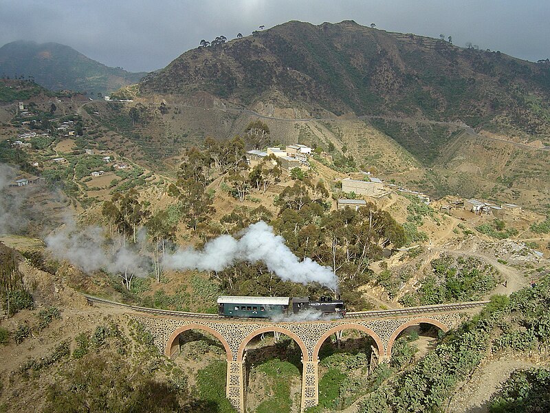
English: Eritrean Railway, showing mountainous terrain traversed between Arbaroba and Asmara.
Български: Еритрейската ЖП линия е посроена през италианското колониално време
Deutsch: Eisenbahn in Eritrea
Esperanto: Fervojoj en Eritreo
Español: Ferrocarril en Eritrea construido por los italianos
Français : Sur les chemins de fer érythréens, actuellement seulement exploités entre Massaoua et Asmara, une locomotive de la série 440 circule sur la section montagneuse entre Arbaroba et Asmara, au niveau de la « porte du Diable »
עברית: רכבת חוצה גשר באריתראה
Bahasa Indonesia: Jalur kereta api Eritrea, yang kini hanya menghubungkan Massawa dan Asmara
Italiano: Una locomotiva della Ferrovia Eritrea mentre attraversa gli altopiani
日本語: 山岳部を走るイタリア領時代に建設されたエリトリア鉄道
Ladino: Tréno en Eritrea de orijin italiano
Polski: Kolej Massaua - Asmara: Lokomotywa klasy 440 na odcinku Arbaroba - Asmara
پښتو: اریتره
Português: A Ferrovia da Eritreia foi construída durante o colonialismo italiano |
| تاریخ | Taken on 4 نومبر 2008 |
| ماخذ | This file was derived from: Eritrean Railway - 2008-11-04.jpg by Voice of Clam |
| اجازت (فائل کا دوبارہ استعمال) |
See below |
| دوسرے نسخے |
|
| Camera | Sony DSC-P12 |
| Notes |
|
| رابطہ کریں | I can be contacted: |
| See also |
|


| Camera location | | View this and other nearby images on: OpenStreetMap |
|---|
اجازہ کاری
| تخلیق کار Voice of Clam نے اس کام کو دائرہ عام میں شائع کیا ہے جس کا اطلاق عالمی سطح پر ہوتا ہے۔ بعض ملکوں میں یہ قانونی طور پر شاید ممکن نہ ہو؛ اگر ایسا ہے تو: Voice of Clam ہر ایک کو کسی بھی مقصد کے لیے بغیر کسی شرط کے اس تصویر کے استعمال کا حق تفویض کرتا/کرتی ہے، بجز اس صورت کے جس میں کوئی قانونی رکاوٹ موجود ہو۔ |
Assessments
|
derivative works
Derivative works of this file: Eritrean Railway banner.jpg
فائل کا تاریخچہ
کسی خاص وقت یا تاریخ میں یہ فائل کیسی نظر آتی تھی، اسے دیکھنے کے لیے اس وقت/تاریخ پر کلک کریں۔
| تاریخ/وقت | تھمب نیل | ابعاد | صارف | تبصرہ | |
|---|---|---|---|---|---|
| رائج الوقت | 18:55، 8 نومبر 2009ء | | 2,400 × 1,800 (1.86 MB) | Voice of Clam | As this version is a Featured Image on enwiki, I do not think it is appropriate to replace it without discussion. I will upload the new version with a different name. |
| 05:42، 8 نومبر 2009ء |  | 2,400 × 1,800 (1.87 MB) | Citypeek | white balance | |
| 12:38، 14 نومبر 2008ء |  | 2,400 × 1,800 (1.86 MB) | Jjron | {{User:Tivedshambo/Information |Description={{w|Eritrean Railway}}, showing mountainous terrain traversed between Arbaroba and {{w|Asmara}}. <br>This is an edited version of Image:Eritrean Railway - Tivedshambo 2008-11-04.jpg by jjron |
روابط
درج ذیل 2 صفحات اس فائل کو استعمال کر رہے ہیں:
فائل کا عالمی استعمال
مندرجہ ذیل ویکیوں میں یہ فائل زیر استعمال ہے:
- bg.wikipedia.org پر استعمال
- bs.wikipedia.org پر استعمال
- cy.wikipedia.org پر استعمال
- de.wikipedia.org پر استعمال
- en.wikipedia.org پر استعمال
- Eritrean Railway
- 1911 in rail transport
- Portal:Africa/Featured picture
- Wikipedia:Featured pictures thumbs/14
- Wikipedia:Picture peer review/Archives/Oct-Dec 2008
- Wikipedia:Picture peer review/Eritrean Railway
- Wikipedia:Featured picture candidates/Eritrean Railway
- Wikipedia:Wikipedia Signpost/2009-01-03/Features and admins
- Wikipedia:Featured picture candidates/December-2008
- Portal:Africa/Featured picture/29
- Wikipedia:Picture of the day/September 2009
- Template:POTD/2009-09-15
- User talk:Sarah777/Archive 25
- Portal:Eritrea/Featured picture
- Portal:Eritrea/Featured article
- Portal:Eritrea/Featured picture/8
- Wikipedia:Featured pictures/Vehicles/Land
- Wikipedia:Wikipedia Signpost/2010-09-20/WikiProject report
- User talk:Voice of Clam/Archives/2008
- User talk:Voice of Clam/Archives/2009
- List of companies based in Eritrea
- Portal:Trains/Selected article/2014 archive
- Portal:Trains/Selected article/Week 34, 2014
- Wikipedia:Wikipedia Signpost/2009-01-03/SPV
- Wikipedia:Wikipedia Signpost/Single/2010-09-20
- User talk:Voice of Clam/Archives
- Portal:Trains/Did you know/December 2016
- User:Alb2017/sandbox
- Italian colonial railways
- Portal:Eritrea/Featured article/7
- User:Moonraker/P
- Wikipedia:Wikipedia Signpost/Single/2009-01-03
- eo.wikipedia.org پر استعمال
- es.wikipedia.org پر استعمال
- fa.wikipedia.org پر استعمال
- fr.wikipedia.org پر استعمال
- ha.wikipedia.org پر استعمال
- he.wikipedia.org پر استعمال
اس فائل کا مزید عالمی استعمال دیکھیے۔