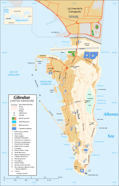
اصل فائل(ایس وی جی فائل، ابعاد 2,020 × 3,140 پکسل، فائل کا حجم: 289 کلوبائٹ)

یہ فائل ویکی ذخائر کی ہے اور دیگر منصوبوں کے زیر استعمال ہوسکتی ہے۔ فائل کے صفحہ تعارف پر موجود تعارف ذیل میں موجود ہے۔

تصویر of the year
تصویر of the year
Featured تصویر

ویکی ذخائر

This file was a candidate in Picture of the Year 2007.
This is a featured picture on Wikimedia Commons (Featured pictures) and is considered one of the finest images. See its nomination here.

If you have an image of similar quality that can be published under a suitable copyright license, be sure to upload it, tag it, and nominate it.

خلاصہ

Camera location36° 08′ 00″ N, 5° 21′ 00″ W Kartographer map based on OpenStreetMap.View this and other nearby images on: OpenStreetMapinfo
تفصیل
Čeština: Mapa ostrova Gibraltar v angličtině.
English: Map in English of Gibraltar.
Français : * Sujet : Carte en anglais de Gibraltar ;
  • Sources : Création personnelle ;
  • Carte créée à partir de captures d'écran d'images satellite de Google Earth d'un point de vue placé à 1,18 km d'altitude (imagerie disponible de novembre 2007) ;
  • Références complémentaires :
  • Échelle approximative : 1:40 000 (précision : environ 10 m) ;
  • Note : Largeur du tracé des routes proportionnelle à la réalité ;
  • Auteur : Eric Gaba (fr:Sting) ;
  • Date : Novembre 2007.
Português: Mapa (em Inglês) de Gibraltar.
تاریخ
ماخذ Own work ;
Map created using screenshots of Google Earth satellite imagery from a point of view located at 1.18 km of altitude (available imagery of November 2007) ;
Other references :
* CIA map ;
* Gibnet map ;
* U.K. MoD map
Locator map : Image:Blank_map_of_South_Europe_and_North_Africa.svg (modified) created by Historicair ;
Approximate scale : 1:40,000 (accuracy : about 10 m)
Note : The roads width is proportional to reality
مصنف Eric Gaba (Sting)
اجازت
(فائل کا دوبارہ استعمال)
Attribution and Share-Alike required
دوسرے نسخے

[ترمیم]

Disputed isthmus and land
SVG genesis
InfoField
 
The SVG code is valid.
 
This map was created with Inkscape…important.
 
 This map uses embedded text that can be easily translated using a text editor.

اجازہ کاری

میں اس کام کا کاپی رائٹ ہولڈر ہوں اور اسے مندرجہ ذیل اجازت ناموں کے تحت شائع کیا ہے:
GNU head آپ کو آزاد سافٹ ویئر فاؤنڈیشن کی جانب سے شائع کردہ جی این یو آزاد مسوداتی اجازت نامہ کی شرائط استعمال کے تحت اس دستاویز کو نقل، تقسیم اور/ یا ترمیم کرنے کی اجازت دی جاتی ہے۔ اس اجازت نامہ کی ایک نقل 'جی این یو آزاد مسوداتی اجازت نامہ کے عنوان سے میسر ہے۔
w:en:Creative Commons
انتساب یکساں شراکت
This file is licensed under the Creative Commons Attribution-Share Alike Attribution-Share Alike 4.0 International, 3.0 Unported, 2.5 Generic, 2.0 Generic and 1.0 Generic license.
آپ آزاد ہیں:
  • شیئر کرنے – کام کو نقل، تقسیم یا منتقل کرنے کے لیے
  • ریمکس کے لیے – کام منبطق کرنے کے لیے
مندرجہ ذیل شرائط کے تحت:
  • انتساب – آپ کو اس کام کا انتساب مصنف یا اجازت دہندہ کے بتائے گئے طریقہ کے مطابق دینا ہوگا (تاہم یہ انتساب اس طرح نہیں ہونا چاہیے کہ اسے دیکھ کر ایسا محسوس ہو کہ اصل مصنف یا اجازت دہندہ آپ کے یا آپ کے ذریعہ اس کام کے استعمال کرنے کے حامی ہیں)۔
  • یکساں شراکت – اگر آپ اس کام میں کوئی تبدیلی یا ترمیم کرتے ہیں یا اس کام پر مبنی کچھ نیا بناتے ہیں تو اسے بھی آپ اسی یا اس جیسے کسی اجازت نامے کے تحت شائع کر سکتے ہیں۔
آپ حسب منشا اجازت نامہ منتخب کر سکتے ہیں۔

Captions

Add a one-line explanation of what this file represents

Items portrayed in this file

عکاسی

نومبر 2007

36°7'59.999"N, 5°21'0.000"W

media type انگریزی

image/svg+xml

فائل کا تاریخچہ

کسی خاص وقت یا تاریخ میں یہ فائل کیسی نظر آتی تھی، اسے دیکھنے کے لیے اس وقت/تاریخ پر کلک کریں۔

تاریخ/وقتتھمب نیلابعادصارفتبصرہ
رائج الوقت20:10، 21 فروری 2020ءمورخہ 20:10، 21 فروری 2020ء کا تھمب نیل2,020 × 3,140 (289 کلوبائٹ)JoKalliauermalformed svg (compare firefox/chrome rendering with librsvg-rendering) actually firefox/chrome were correct, also it looks wrong
06:01، 29 جون 2017ءمورخہ 06:01، 29 جون 2017ء کا تھمب نیل2,020 × 3,140 (538 کلوبائٹ)Wereldburger758Removal error in file. Valid SVG now.
21:52، 27 اگست 2008ءمورخہ 21:52، 27 اگست 2008ء کا تھمب نیل2,020 × 3,140 (569 کلوبائٹ)RedCoatRemove "claimed by Spain", completely gratuitous for a map
11:28، 11 دسمبر 2007ءمورخہ 11:28، 11 دسمبر 2007ء کا تھمب نیل2,020 × 3,140 (570 کلوبائٹ)StingNotification of the Spanish claims
14:40، 27 نومبر 2007ءمورخہ 14:40، 27 نومبر 2007ء کا تھمب نیل2,020 × 3,140 (569 کلوبائٹ)StingAdditional names ; up-to-date corrections
21:35، 26 نومبر 2007ءمورخہ 21:35، 26 نومبر 2007ء کا تھمب نیل2,020 × 3,140 (561 کلوبائٹ)RedCoatHouse of Assembly → Gibraltar Parliament
19:51، 26 نومبر 2007ءمورخہ 19:51، 26 نومبر 2007ء کا تھمب نیل2,020 × 3,140 (561 کلوبائٹ)Sting+ info
14:12، 26 نومبر 2007ءمورخہ 14:12، 26 نومبر 2007ء کا تھمب نیل2,020 × 3,140 (561 کلوبائٹ)Sting+ info
13:21، 26 نومبر 2007ءمورخہ 13:21، 26 نومبر 2007ء کا تھمب نیل2,020 × 3,140 (561 کلوبائٹ)Sting{{Information |Description=Map in English of Gibraltar |Source=Own work ;<br/>Map created using screenshots of Google Earth satellite imagery from a point of view located at 1.18 km of altitude (available image

اس فائل سے مربوط کوئی صفحہ موجود نہیں ہے۔

فائل کا عالمی استعمال

مندرجہ ذیل ویکیوں میں یہ فائل زیر استعمال ہے:

میٹا ڈیٹا