فائل:Greater London boroughs 2009 map.svg

اصل فائل (ایس وی جی فائل، ابعاد 1,425 × 1,140 پکسل، فائل کا حجم: 761 کلوبائٹ)
خلاصہ
| تفصیل |
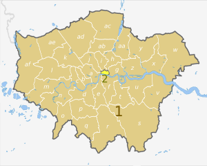
English: Map of Greater London, UK with districts shown, in the same style as other maps of English regions. The county colours are the same as those in File:English metropolitan and non-metropolitan counties 2009.svg.
Equirectangular map projection on WGS 84 datum, with N/S stretched 160%. Geographic limits:
|
| تاریخ | (UTC) |
| ماخذ |
This file was derived from: Greater London UK district map (blank).svg: |
| مصنف |
|
.svg)
| Map | Ceremonial county | London boroughs |
|---|---|---|
 |
1. Greater London |
a) City of Westminster, b) Kensington and Chelsea, c) Hammersmith and Fulham, d) Wandsworth, e) Lambeth, f) Southwark, g) Tower Hamlets, h) Hackney, i) Islington, j) Camden, k) Brent, l) Ealing, m) Hounslow, n) Richmond, o) Kingston upon Thames, p) Merton, q) Sutton, r) Croydon, s) Bromley, t) Lewisham, u) Greenwich, v) Bexley, w) Havering, x) Barking and Dagenham, y) Redbridge, z) Newham, aa) Waltham Forest, ab) Haringey, ac) Enfield, ad) Barnet, ae) Harrow, af) Hillingdon |
| 2. City of London | ||
| This is a retouched picture, which means that it has been digitally altered from its original version. Modifications: recoloured and labelled in same style as other English regional maps. The original can be viewed here: Greater London UK district map (blank).svg:
|
اجازہ کاری
- آپ آزاد ہیں:
- شیئر کرنے – کام کو نقل، تقسیم یا منتقل کرنے کے لیے
- ریمکس کے لیے – کام منبطق کرنے کے لیے
- مندرجہ ذیل شرائط کے تحت:
- انتساب – آپ کو اس کام کا انتساب مصنف یا اجازت دہندہ کے بتائے گئے طریقہ کے مطابق دینا ہوگا (تاہم یہ انتساب اس طرح نہیں ہونا چاہیے کہ اسے دیکھ کر ایسا محسوس ہو کہ اصل مصنف یا اجازت دہندہ آپ کے یا آپ کے ذریعہ اس کام کے استعمال کرنے کے حامی ہیں)۔
- یکساں شراکت – اگر آپ اس کام میں کوئی تبدیلی یا ترمیم کرتے ہیں یا اس کام پر مبنی کچھ نیا بناتے ہیں تو اسے بھی آپ اسی یا اس جیسے کسی اجازت نامے کے تحت شائع کر سکتے ہیں۔
اولین اپلوڈ کا نوشتہ
This image is a derivative work of the following images:
- File:Greater_London_UK_district_map_(blank).svg licensed with Cc-by-sa-3.0
- 2010-08-22T08:09:33Z Nilfanion 1425x1140 (1104179 Bytes) +inset, water colour tweak
- 2010-07-16T23:35:33Z Nilfanion 1425x1140 (738807 Bytes) {{Information |Description=Map of [[w:Greater London|Greater London]], UK with districts shown. Equirectangular map projection on WGS 84 datum, with N/S stretched 160% Geographic limits: *West: 0.57W *East: 0.37E *North: 51
Uploaded with derivativeFX
فائل کا تاریخچہ
کسی خاص وقت یا تاریخ میں یہ فائل کیسی نظر آتی تھی، اسے دیکھنے کے لیے اس وقت/تاریخ پر کلک کریں۔
| تاریخ/وقت | تھمب نیل | ابعاد | صارف | تبصرہ | |
|---|---|---|---|---|---|
| رائج الوقت | 22:05، 2 مئی 2012ء | | 1,425 × 1,140 (761 کلوبائٹ) | Dr Greg | == {{int:filedesc}} == {{Information |Description={{en|Map of Greater London, UK with districts shown, in the same style as other maps of English regions. The county colours are the same as those in [[:File:English metropolitan and... |
روابط
درج ذیل صفحہ اس فائل کو استعمال کر رہا ہے:
فائل کا عالمی استعمال
مندرجہ ذیل ویکیوں میں یہ فائل زیر استعمال ہے:
- ar.wikipedia.org پر استعمال
- de.wikipedia.org پر استعمال
- en.wikipedia.org پر استعمال
- fr.wikipedia.org پر استعمال
- pnb.wikipedia.org پر استعمال
- th.wikipedia.org پر استعمال
- zh-yue.wikipedia.org پر استعمال