اصل فائل (1,200 × 1,152 پکسل، فائل کا حجم: 901 کلوبائٹ، MIME قسم: image/jpeg)

یہ فائل ویکی ذخائر کی ہے اور دیگر منصوبوں کے زیر استعمال ہوسکتی ہے۔ فائل کے صفحہ تعارف پر موجود تعارف ذیل میں موجود ہے۔

خلاصہ

تفصیل
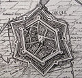
English: Grol (Groenlo) in 1627, detail of a bigger map portraying the Siege of Groenlo in 1627 by Frederick Henry. Siege works (approches) are visible.
Nederlands: Grol (Groenlo) anno 1627, detail van een grotere kaart met de belegering van Groenlo door Frederik Hendrik in 1627. Belegeringswerken zoals approches zijn zichtbaar.
تاریخ
ماخذ Belegeringe Der Starcke Stadt Groll
مصنف
Claes Janszoon Visscher II  (1586–1652)  wikidata:Q1094674
 
متبادل نام
Claes Jansz. Visscher (II), Claes Janszoon Visscher, Joannes Piscator, Nicolas Jansz. Visscher (II),
Nicolas Joannis Visscher (II)
تفصیل Dutch publisher، printmaker اور drawer
تاریخ پیدائش/وفات 1587 / 1586 / بین 1,586.0 و 1,587.0
date QS:P,+1586-00-00T00:00:00Z/8,P1319,+1586-00-00T00:00:00Z/9,P1326,+1587-00-00T00:00:00Z/9
 Edit this at Wikidata
19 جون 1652 Edit this at Wikidata
مقام پیدائش/وفات ایمسٹرڈیم Edit this at Wikidata ایمسٹرڈیم Edit this at Wikidata
مدتِ کار قریباً بین 1,601.0 و 1,652.0
date QS:P,+1650-00-00T00:00:00Z/7,P1319,+1601-00-00T00:00:00Z/9,P1326,+1652-00-00T00:00:00Z/9,P1480,Q5727902
مقامِ کار
ایمسٹرڈیم (1605–1652) Edit this at Wikidata
تضبیط سند
creator QS:P170,Q1094674

اجازہ کاری

Public domain

This work is in the public domain in its country of origin and other countries and areas where the copyright term is the author's life plus 100 years or fewer.


You must also include a United States public domain tag to indicate why this work is in the public domain in the United States.
This file has been identified as being free of known restrictions under copyright law, including all related and neighboring rights.

Captions

Add a one-line explanation of what this file represents

Items portrayed in this file

عکاسی

captured with انگریزی

Canon PowerShot S5 IS انگریزی

media type انگریزی

image/jpeg

فائل کا تاریخچہ

کسی خاص وقت یا تاریخ میں یہ فائل کیسی نظر آتی تھی، اسے دیکھنے کے لیے اس وقت/تاریخ پر کلک کریں۔

تاریخ/وقتتھمب نیلابعادصارفتبصرہ
رائج الوقت09:40، 19 ستمبر 2008ءمورخہ 09:40، 19 ستمبر 2008ء کا تھمب نیل1,200 × 1,152 (901 کلوبائٹ)Kweniston{{Information |Description={{en|1=Grol (Groenlo) in 1627, detail of a bigger map portraying the Siege of Groenlo in 1627 by Frederick Henry. Siege works (approches) are visible.}} {{nl|1=Grol (Groenlo) anno 1627, detail van een grotere kaart met de belege

درج ذیل صفحہ اس فائل کو استعمال کر رہا ہے:

فائل کا عالمی استعمال

مندرجہ ذیل ویکیوں میں یہ فائل زیر استعمال ہے:

میٹا ڈیٹا