فائل:Historic Stevens Trail CA.JPG

اس نمائش کا حجم: 800 × 533 پکسلز۔ دیگر تصمیمات: 320 × 213 پکسلز | 640 × 427 پکسلز | 960 × 640 پکسلز۔
اصل فائل (960 × 640 پکسل، فائل کا حجم: 200 کلوبائٹ، MIME قسم: image/jpeg)
| تفصیل |
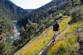
English: The Stevens Trail is a popular year-round hiking trail in the lower elevations of the Sierra Nevada mountain range. Historically, the trail connected the town of Iowa Hill with the city of Colfax, both in Placer County, California.
The current trail extends 4.5 miles along the northwestern slope of the North Fork of the American River Canyon. It begins at the trailhead in Colfax and ends at the confluence of Secret Ravine and the North Fork of the American River. |
|||
| تاریخ | Posted March 6, 2013 | |||
| ماخذ | https://www.facebook.com/blmcalifornia/photos/a.381118831912797.90344.121009507923732/565469790144366/ | |||
| مصنف | CA BLM | |||
| اجازت (فائل کا دوبارہ استعمال) |
|
فائل کا تاریخچہ
کسی خاص وقت یا تاریخ میں یہ فائل کیسی نظر آتی تھی، اسے دیکھنے کے لیے اس وقت/تاریخ پر کلک کریں۔
| تاریخ/وقت | تھمب نیل | ابعاد | صارف | تبصرہ | |
|---|---|---|---|---|---|
| رائج الوقت | 01:07، 30 اگست 2016ء | | 960 × 640 (200 کلوبائٹ) | Tillman | {{Information |Description ={{en|1=The Stevens Trail is a popular year-round hiking trail in the lower elevations of the Sierra Nevada mountain range. Historically, the trail connected the town of Iowa Hill with the city of Colfax, both in Placer Co... |
روابط
درج ذیل صفحہ اس فائل کو استعمال کر رہا ہے:
فائل کا عالمی استعمال
مندرجہ ذیل ویکیوں میں یہ فائل زیر استعمال ہے:
- azb.wikipedia.org پر استعمال
- en.wikipedia.org پر استعمال
- ml.wikipedia.org پر استعمال
- simple.wikipedia.org پر استعمال
- uk.wikipedia.org پر استعمال