فائل:IBCAO betamap.jpg
اس نمائش کا حجم: 526 × 599 پکسلز۔ دیگر تصمیمات: 211 × 240 پکسلز | 421 × 480 پکسلز | 762 × 868 پکسلز۔
اصل فائل (762 × 868 پکسل، فائل کا حجم: 710 کلوبائٹ، MIME قسم: image/jpeg)
| وضاحت |
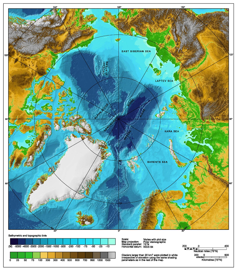
Bathymetric map of the Arctic Ocean |
|||||||||
| ماخذ | http://www.ngdc.noaa.gov/mgg/image/IBCAO_betamap.jpg | |||||||||
| اجازت (فائل کا دوبارہ استعمال) |
|
|||||||||
| Geotemporal data | ||||||||||
| Bounding box |
|
|||||||||
| Georeferencing | ||||||||||
| دوسرے نسخے |
Derivative works of this file: |
|||||||||
فائل کا تاریخچہ
کسی خاص وقت یا تاریخ میں یہ فائل کیسی نظر آتی تھی، اسے دیکھنے کے لیے اس وقت/تاریخ پر کلک کریں۔
| تاریخ/وقت | تھمب نیل | ابعاد | صارف | تبصرہ | |
|---|---|---|---|---|---|
| رائج الوقت | 00:29، 2 اگست 2007ء | | 762 × 868 (710 کلوبائٹ) | Mikkalai | Source: http://www.ngdc.noaa.gov/mgg/image/IBCAO_betamap.jpg Bathymetric map of the w:Arctic Ocean |
روابط
اس فائل سے مربوط کوئی صفحہ موجود نہیں ہے۔
فائل کا عالمی استعمال
مندرجہ ذیل ویکیوں میں یہ فائل زیر استعمال ہے:
- af.wikipedia.org پر استعمال
- ar.wikipedia.org پر استعمال
- ary.wikipedia.org پر استعمال
- ast.wikipedia.org پر استعمال
- avk.wikipedia.org پر استعمال
- azb.wikipedia.org پر استعمال
- bcl.wikipedia.org پر استعمال
- be.wikipedia.org پر استعمال
- bg.wikipedia.org پر استعمال
- bh.wikipedia.org پر استعمال
- bn.wikipedia.org پر استعمال
- bxr.wikipedia.org پر استعمال
- ca.wikipedia.org پر استعمال
- ceb.wikipedia.org پر استعمال
- chr.wikipedia.org پر استعمال
- co.wikipedia.org پر استعمال
- crh.wikipedia.org پر استعمال
- cs.wikipedia.org پر استعمال
- da.wikipedia.org پر استعمال
- de.wikipedia.org پر استعمال
- dty.wikipedia.org پر استعمال
- en.wikipedia.org پر استعمال
- Talk:Lomonosov Ridge
- Territorial claims in the Arctic
- Arktika 2007
- Portal:Maps/Maps/Geographic
- Portal:Maps/Maps/Geographic/2
- Arctic Ocean
- User:Wiki User 68/My Portal/Selected geography/1
- List of Russian explorers
- Wikipedia:Reference desk/Archives/Science/2015 May 29
- User:Joelton Ivson/Gather lists/24441 – Conflitos internacionais
- User:Godsy/Portal example
- en.wikinews.org پر استعمال
- en.wikiversity.org پر استعمال
- eo.wikipedia.org پر استعمال
- es.wikipedia.org پر استعمال
اس فائل کا مزید عالمی استعمال دیکھیے۔