فائل:ISS018-E-7727 NASA Asau Savai'i, Samoa.jpg

اس نمائش کا حجم: 800 × 532 پکسلز۔ دیگر تصمیمات: 320 × 213 پکسلز | 640 × 426 پکسلز | 1,024 × 681 پکسلز | 1,280 × 851 پکسلز | 2,560 × 1,703 پکسلز | 4,312 × 2,868 پکسلز۔
اصل فائل (4,312 × 2,868 پکسل، فائل کا حجم: 2.97 MB، MIME قسم: image/jpeg)
خلاصہ
| تفصیل |
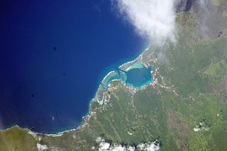
English: Savai'i island, north west coast, reefs, Asau taken by NASA at an altitude of 192 nautical miles (356 km)
Gagana Samoa: Le Itu Asau, Savai'i (le ata mai NASA)
Русский: Район Асау на острове Савайи в Самоа. Фото с сайта НАСА. |
| تاریخ | |
| ماخذ |
<http://eol.jsc.nasa.gov/scripts/sseop/photo.pl?mission=ISS018&roll=E&frame=7727> (). Image Science and Analysis Laboratory, NASA-Johnson Space Center. "The Gateway to Astronaut Photography of Earth." |
| مصنف |
NASA
|
| Camera location | | View this and other nearby images on: OpenStreetMap |
|---|
This image or video was catalogued by Kennedy Space Center of the United States National Aeronautics and Space Administration (NASA) under Photo ID: ISS018-E-7727. This tag does not indicate the copyright status of the attached work. A normal copyright tag is still required. See Commons:Licensing. Other languages:
|
اجازہ کاری
This file is in the public domain in the United States because it was created by the Image Science & Analysis Laboratory, of the NASA Johnson Space Center. NASA copyright policy states that "NASA material is not protected by copyright unless noted". (NASA media use guidelines or Conditions of Use of Astronaut Photographs).
Photo source: ISS018-E-7727.
|
فائل کا تاریخچہ
کسی خاص وقت یا تاریخ میں یہ فائل کیسی نظر آتی تھی، اسے دیکھنے کے لیے اس وقت/تاریخ پر کلک کریں۔
| تاریخ/وقت | تھمب نیل | ابعاد | صارف | تبصرہ | |
|---|---|---|---|---|---|
| رائج الوقت | 22:48، 26 مئی 2013ء | | 4,312 × 2,868 (2.97 MB) | Ras67 | new rendered from NASA's raw image file, 180 degree rotated |
| 13:03، 25 جنوری 2010ء |  | 640 × 437 (50 کلوبائٹ) | Teinesavaii | {{Information |Description={{en|1=Savai'i island, north west coast, reefs, Asau taken by NASA at an altitude of 192 nautical miles (356 km)}} |Source=<http://eol.jsc.nasa.gov/scripts/sseop/photo.pl?mission=ISS018&roll=E&frame=7727> (). Image Science and A |
روابط
درج ذیل صفحہ اس فائل کو استعمال کر رہا ہے:
فائل کا عالمی استعمال
مندرجہ ذیل ویکیوں میں یہ فائل زیر استعمال ہے:
- bn.wikipedia.org پر استعمال
- en.wikipedia.org پر استعمال
- it.wikipedia.org پر استعمال
- mrj.wikipedia.org پر استعمال
- sk.wikipedia.org پر استعمال
- uk.wikipedia.org پر استعمال
- www.wikidata.org پر استعمال