فائل:Italy 1000 AD-de.svg

اصل فائل (ایس وی جی فائل، ابعاد 572 × 819 پکسل، فائل کا حجم: 334 کلوبائٹ)
خلاصہ
| تفصیل |
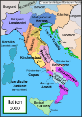
English: Political map of Italy in 1000 AD (CE). German translation of Image:Italy_1000_AD.svg which was created by MapMaster.
Part of a series of maps on the history of Italy:
|
| تاریخ | 20 دسمبر 2007 (original upload date) |
| ماخذ | No machine-readable source provided. Own work assumed (based on copyright claims). |
| مصنف | No machine-readable author provided. Bamse assumed (based on copyright claims). |
| دوسرے نسخے |
[]
SVG:
PNG:
|


|
یہ ایس وی جی (SVG) فائل نصب شدہ متن (ایمبیڈڈ ٹیکسٹ) پر مشتمل ہے، جسے کسی بھی SVG ایڈیٹر یا ٹیکسٹ ایڈیٹر کا استعمال کرتے ہوئے یا SVG آلہ ترجمہ کی معاونت سے آپ کی زبان میں ترجمہ کیا جا سکتا ہے۔ مزید معلومات کے لیے دیکھیے: SVG فائلوں کا ترجمہ۔ |
References
- Bjorklund, Oddvar; Holmboe, Haakon; Rohr, Anders (1970) Historical Atlas of the World, Barnes & Noble, NY, SBN: 389-00253-4.
- This map from Allyn & Bacon, Longman, textbook publishers.
- This map of the w:en:Holy Roman Empire
- A map from Attilios
- This map of 1050 AD Italy, from the 1923 The Historical Atlas by William R. Shepherd
- This map of 1000 AD Italy from Fordham University, adapted from Muir's Historical Atlas, (1911).
In addition, a number of other sources were consulted in an effort to determine the following matters:
- The extent of Venetian control over the cities of Dalmatia such as Zara and Spalato. Although the Venetians had been pushed off the mainland earlier, in the period around the year 1000, the Venetians made an effort to recover these cities.
- The extent of Saracen control over Corsica and Sardinia. Information is sparse. The apparent situation is that the Muslims had several bases on the coasts of these islands, but did not control the countryside (such as they did in Sicily).
- Whether or not the principalities of Capua and Benevento were separate states in the year 1000. Based on lists of their rulers (various Pandulfs and Landulfs), the answer seems to be "yes".
- Who controlled the Balkans on the southeastern border of the Kingdom of Croatia. Candidates include Bulgaria, the Byzantine Empire, Croatia, and Serbia.
As noted, there is significant disagreement among sources on these questions.
This map was commissioned by Attilios, and there is also a discussion to be found on MapMaster's English talk page.
اجازہ کاری

|
آپ کو آزاد سافٹ ویئر فاؤنڈیشن کی جانب سے شائع کردہ جی این یو آزاد مسوداتی اجازت نامہ کی شرائط استعمال کے تحت اس دستاویز کو نقل، تقسیم اور/ یا ترمیم کرنے کی اجازت دی جاتی ہے۔ اس اجازت نامہ کی ایک نقل 'جی این یو آزاد مسوداتی اجازت نامہ کے عنوان سے میسر ہے۔ |
| اس ملف کا لائسنس Creative Commons Attribution-Share Alike 3.0 Unported کے تحط ہے۔ | ||
| ||
| This licensing tag was added to this file as part of the GFDL licensing update. |
فائل کا تاریخچہ
کسی خاص وقت یا تاریخ میں یہ فائل کیسی نظر آتی تھی، اسے دیکھنے کے لیے اس وقت/تاریخ پر کلک کریں۔
| تاریخ/وقت | تھمب نیل | ابعاد | صارف | تبصرہ | |
|---|---|---|---|---|---|
| رائج الوقت | 16:36، 11 اپریل 2009ء | | 572 × 819 (334 کلوبائٹ) | Rhegion | aggiunta Reggio |
| 08:05، 20 دسمبر 2007ء |  | 572 × 819 (332 کلوبائٹ) | Bamse | == Summary == '''de:''' Political map of Italy in 1000 AD (CE). German translation of Image:Italy_1000_AD.svg which was created by MapMaster. Part of a series of maps on the history of Italy: <gallery> Image:Italy and Illyria 1084 v2.svg|1084 AD Im |
روابط
اس فائل سے مربوط کوئی صفحہ موجود نہیں ہے۔
فائل کا عالمی استعمال
مندرجہ ذیل ویکیوں میں یہ فائل زیر استعمال ہے:
- da.wikipedia.org پر استعمال
- de.wikipedia.org پر استعمال
- 1011
- 1016
- 1018
- 1000
- Korsika
- Mark (Territorium)
- Etrurien
- Pietro II. Orseolo
- Herzogtum Benevent
- Herzogtum Spoleto
- Pietro II. Candiano
- Markgrafschaft Verona
- Pietro Orseolo
- Fürstentum Capua
- Pietro Badoer
- Vitale Candiano
- Tribuno Memmo
- Wikipedia:Kartenwerkstatt/Archiv/2007-12
- Herzogtum Amalfi
- Normannische Eroberung Süditaliens
- Katepanat Italien
- Abu l-Qasim (Emir)
- Hassan al-Kalbi
- Ottone Orseolo
- Pietro III. Candiano
- Pietro IV. Candiano
- Civita
- Nikephoros Phokas der Ältere
- Pandulf I.
- Italien-Runensteine
- Benutzer:Methodios/Boioannes
- Giovanni Orseolo
- Emirat von Sizilien
- Markgrafschaft Tuscien
- Waldrada (ductrix)
- Cesina
- Liste der historischen Staaten in Italien
- Maria (ductrix)
- Johanna (ductrix)
- Italienische Münzgeschichte
- de.wikibooks.org پر استعمال
- de.wikiversity.org پر استعمال
- eo.wikipedia.org پر استعمال
- nl.wikipedia.org پر استعمال
- uk.wikipedia.org پر استعمال