فائل:Kars Panorama.JPG
اس نمائش کا حجم: 800 × 343 پکسلز۔ دیگر تصمیمات: 320 × 137 پکسلز | 640 × 274 پکسلز | 1,024 × 439 پکسلز | 1,280 × 549 پکسلز | 2,560 × 1,097 پکسلز | 5,647 × 2,420 پکسلز۔
اصل فائل (5,647 × 2,420 پکسل، فائل کا حجم: 4.82 MB، MIME قسم: image/jpeg)
|
خلاصہ
| تفصیل |
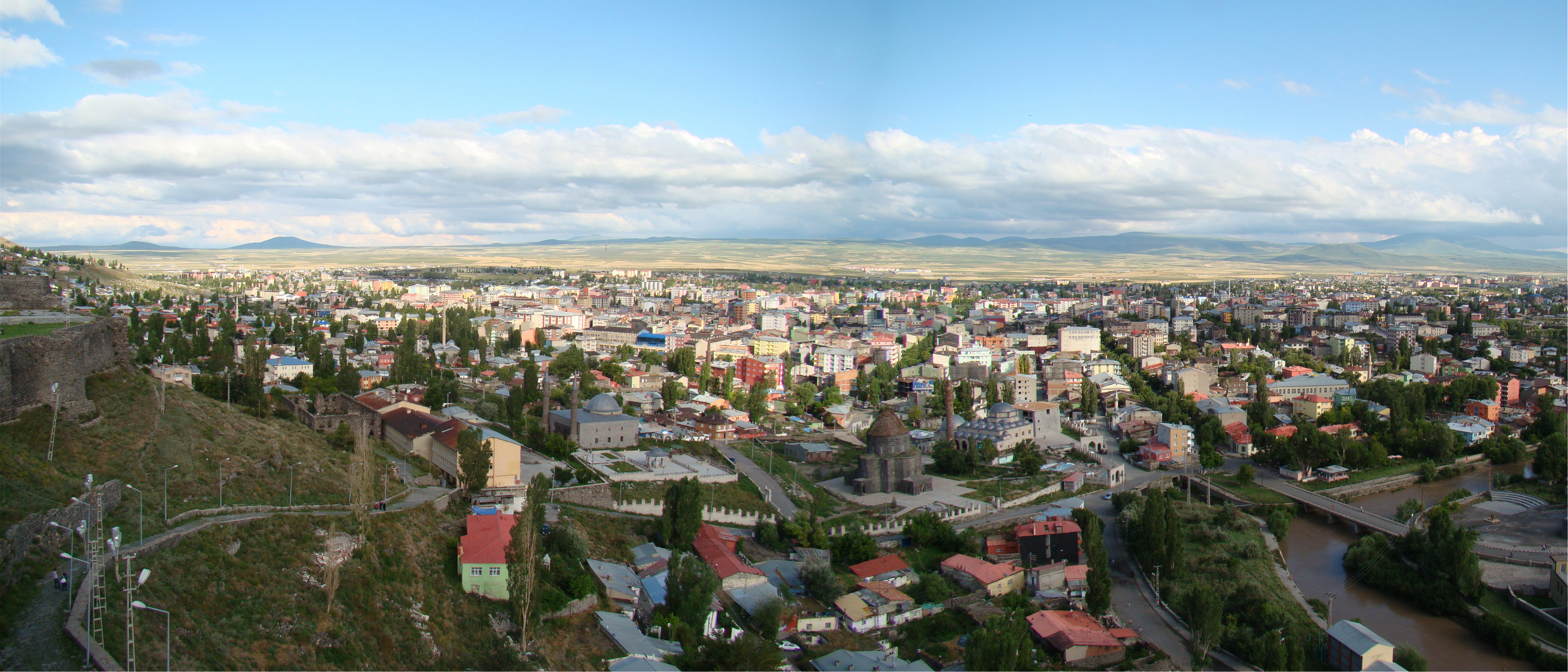
English: A panorama from the fortress above Kars, Turkey, looking south-west from the north-east side of the city. On the left edge of the photo you can see some of the fortress walls, and a graveyard in the distance. Below the hill straight ahead is the original Armenian Church of the Apostles dating from 939 AD, which since 1998 has been a mosque. Behind it on the right is the Evliya Mosque
The water flowing past the church/mosque is the Kars Canal. |
| تاریخ | |
| ماخذ | Own work by uploader, http://bjornfree.com/galleries.html |
| مصنف | Bjørn Christian Tørrissen |
| Camera location | | View this and other nearby images on: OpenStreetMap |
|---|
اجازہ کاری
میں اس کام کا کاپی رائٹ ہولڈر ہوں اور اسے مندرجہ ذیل اجازت ناموں کے تحت شائع کیا ہے:
اس ملف کا لائسنس Creative Commons Attribution-Share Alike 3.0 Unported کے تحط ہے۔
- آپ آزاد ہیں:
- شیئر کرنے – کام کو نقل، تقسیم یا منتقل کرنے کے لیے
- ریمکس کے لیے – کام منبطق کرنے کے لیے
- مندرجہ ذیل شرائط کے تحت:
- انتساب – آپ کو اس کام کا انتساب مصنف یا اجازت دہندہ کے بتائے گئے طریقہ کے مطابق دینا ہوگا (تاہم یہ انتساب اس طرح نہیں ہونا چاہیے کہ اسے دیکھ کر ایسا محسوس ہو کہ اصل مصنف یا اجازت دہندہ آپ کے یا آپ کے ذریعہ اس کام کے استعمال کرنے کے حامی ہیں)۔
- یکساں شراکت – اگر آپ اس کام میں کوئی تبدیلی یا ترمیم کرتے ہیں یا اس کام پر مبنی کچھ نیا بناتے ہیں تو اسے بھی آپ اسی یا اس جیسے کسی اجازت نامے کے تحت شائع کر سکتے ہیں۔

|
آپ کو آزاد سافٹ ویئر فاؤنڈیشن کی جانب سے شائع کردہ جی این یو آزاد مسوداتی اجازت نامہ کی شرائط استعمال کے تحت اس دستاویز کو نقل، تقسیم اور/ یا ترمیم کرنے کی اجازت دی جاتی ہے۔ اس اجازت نامہ کی ایک نقل 'جی این یو آزاد مسوداتی اجازت نامہ کے عنوان سے میسر ہے۔ |
آپ حسب منشا اجازت نامہ منتخب کر سکتے ہیں۔
فائل کا تاریخچہ
کسی خاص وقت یا تاریخ میں یہ فائل کیسی نظر آتی تھی، اسے دیکھنے کے لیے اس وقت/تاریخ پر کلک کریں۔
| تاریخ/وقت | تھمب نیل | ابعاد | صارف | تبصرہ | |
|---|---|---|---|---|---|
| رائج الوقت | 19:08، 1 نومبر 2009ء | | 5,647 × 2,420 (4.82 MB) | Uspn | {{Information |Description={{en|1=A panorama from the fortress above Kars, Turkey. On the left edge of the photo you can see some of the fortress walls, and a graveyard in the distance. Below the hill straight ahead is the original Armenian Church of the |
روابط
درج ذیل صفحہ اس فائل کو استعمال کر رہا ہے:
فائل کا عالمی استعمال
مندرجہ ذیل ویکیوں میں یہ فائل زیر استعمال ہے:
- ab.wikipedia.org پر استعمال
- ar.wikipedia.org پر استعمال
- arz.wikipedia.org پر استعمال
- ast.wikipedia.org پر استعمال
- be.wikipedia.org پر استعمال
- ca.wikipedia.org پر استعمال
- ce.wikipedia.org پر استعمال
- da.wikipedia.org پر استعمال
- de.wikivoyage.org پر استعمال
- diq.wikipedia.org پر استعمال
- el.wikipedia.org پر استعمال
- en.wikipedia.org پر استعمال
- en.wikivoyage.org پر استعمال
- eu.wikipedia.org پر استعمال
- fa.wikipedia.org پر استعمال
- fr.wikivoyage.org پر استعمال
- he.wikipedia.org پر استعمال
- hyw.wikipedia.org پر استعمال
- id.wikipedia.org پر استعمال
- it.wikipedia.org پر استعمال
- ko.wikipedia.org پر استعمال
- lv.wikipedia.org پر استعمال
- mdf.wikipedia.org پر استعمال
- mk.wikipedia.org پر استعمال
- mrj.wikipedia.org پر استعمال
- nl.wikipedia.org پر استعمال
- nn.wikipedia.org پر استعمال
- pl.wikipedia.org پر استعمال
- pnb.wikipedia.org پر استعمال
- ro.wikipedia.org پر استعمال
- ru.wikipedia.org پر استعمال
- sco.wikipedia.org پر استعمال
- sh.wikipedia.org پر استعمال
- so.wikipedia.org پر استعمال
- sq.wikipedia.org پر استعمال
- sr.wikipedia.org پر استعمال
- tg.wikipedia.org پر استعمال
- th.wikipedia.org پر استعمال
- tl.wikipedia.org پر استعمال
اس فائل کا مزید عالمی استعمال دیکھیے۔