فائل:Map-Latin America.png

اس نمائش کا حجم: 800 × 406 پکسلز۔ دیگر تصمیمات: 320 × 162 پکسلز | 640 × 325 پکسلز | 1,272 × 645 پکسلز۔
اصل فائل (1,272 × 645 پکسل، فائل کا حجم: 150 کلوبائٹ، MIME قسم: image/png)

|
This linguistic map image could be re-created using vector graphics as an SVG file. This has several advantages; see Commons:Media for cleanup for more information. If an SVG form of this image is available, please upload it and afterwards replace this template with
{{vector version available|new image name}}.
It is recommended to name the SVG file “Map-Latin America.svg”—then the template Vector version available (or Vva) does not need the new image name parameter. |
خلاصہ

.
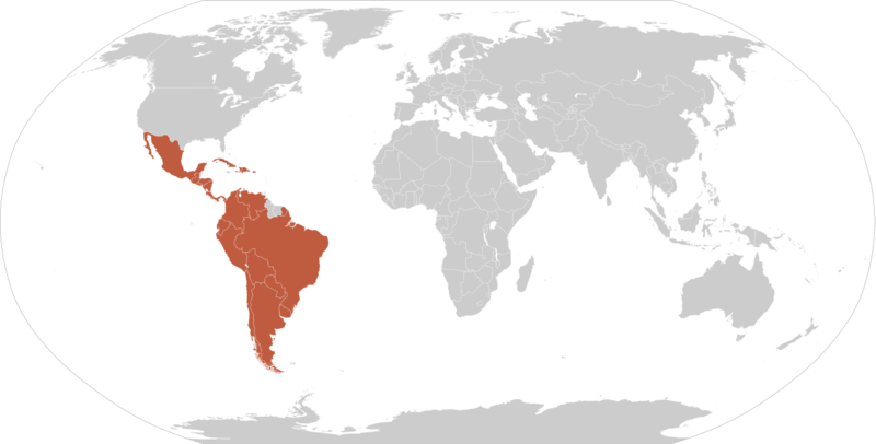
Map of en:Latin america. Thanks to write in the talk page if it's need to improve it. An alternative image is Image:Map-Latin America2.png.
Map made from Image:BlankMap-World.png
اجازہ کاری
| تخلیق کار Yug نے اس کام کو دائرہ عام میں شائع کیا ہے جس کا اطلاق عالمی سطح پر ہوتا ہے۔ بعض ملکوں میں یہ قانونی طور پر شاید ممکن نہ ہو؛ اگر ایسا ہے تو: |
فائل کا تاریخچہ
کسی خاص وقت یا تاریخ میں یہ فائل کیسی نظر آتی تھی، اسے دیکھنے کے لیے اس وقت/تاریخ پر کلک کریں۔
| تاریخ/وقت | تھمب نیل | ابعاد | صارف | تبصرہ | |
|---|---|---|---|---|---|
| رائج الوقت | 04:33، 14 مئی 2016ء | | 1,272 × 645 (150 کلوبائٹ) | Elevatorrailfan | Fixing |
| 03:07، 14 مئی 2016ء |  | 1,272 × 645 (149 کلوبائٹ) | Elevatorrailfan | No need to have Brazil and French speaking countries in a separate shade. | |
| 16:02، 20 مارچ 2011ء |  | 1,356 × 688 (158 کلوبائٹ) | Philip Stevens | The Falkland Islands, South Georgia and the South Sandwich Islands are not part of Latin America. | |
| 07:33، 12 مارچ 2010ء |  | 1,356 × 688 (167 کلوبائٹ) | Fenixt | (Iberoamérica. Nombre que recibe el conjunto de países americanos que formaron parte de los reinos de España y Portugal http://buscon.rae.es/dpdI/SrvltConsulta?lema=iberoam%C3%A9rica) | |
| 04:19، 28 اکتوبر 2008ء |  | 1,357 × 628 (25 کلوبائٹ) | Denis C.~commonswiki | Reverted to old version because previous image had Quebec colored on the map but with very inaccurate border lines. Also, Quebec is not even considered a part of Latin America according to the article about the latter and its inhabitants don't consider it | |
| 07:05، 20 اکتوبر 2008ء |  | 1,357 × 628 (29 کلوبائٹ) | Pruxo | guyana not exactly part (french colony) Belize english origin, Quevec french culture, (as martinica, haiti, etc) | |
| 16:32، 17 ستمبر 2008ء |  | 1,357 × 628 (16 کلوبائٹ) | Chesnok | {{Information |Description= |Source= |Date= |Author= |Permission= |other_versions= }} | |
| 13:13، 10 دسمبر 2005ء |  | 1,357 × 628 (25 کلوبائٹ) | Yug | Map of en:Latin america. Thanks to write in the talk page if it's need to improve it. en:Latin america fr:Amérique latine Map made from Image:BlankMap-World.png {{PD-user|Yug}} Category:World maps |
روابط
درج ذیل صفحہ اس فائل کو استعمال کر رہا ہے:
فائل کا عالمی استعمال
مندرجہ ذیل ویکیوں میں یہ فائل زیر استعمال ہے:
- arc.wikipedia.org پر استعمال
- be-tarask.wikipedia.org پر استعمال
- bn.wikipedia.org پر استعمال
- br.wikipedia.org پر استعمال
- ceb.wikipedia.org پر استعمال
- cs.wikipedia.org پر استعمال
- dv.wikipedia.org پر استعمال
- en.wikipedia.org پر استعمال
- eo.wikipedia.org پر استعمال
- eo.wikinews.org پر استعمال
- es.wikipedia.org پر استعمال
- fr.wikipedia.org پر استعمال
- fr.wikinews.org پر استعمال
- fy.wikipedia.org پر استعمال
- ga.wikipedia.org پر استعمال
- gl.wikipedia.org پر استعمال
اس فائل کا مزید عالمی استعمال دیکھیے۔