فائل:Map of Ancient Rome 271 AD.svg

اصل فائل (ایس وی جی فائل، ابعاد 2,050 × 1,213 پکسل، فائل کا حجم: 207 کلوبائٹ)
خلاصہ
| تفصیل |
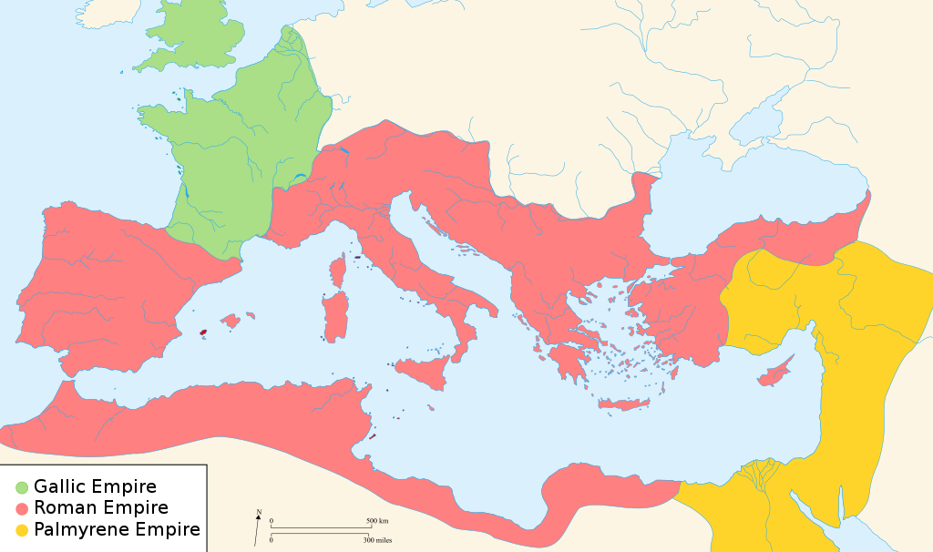
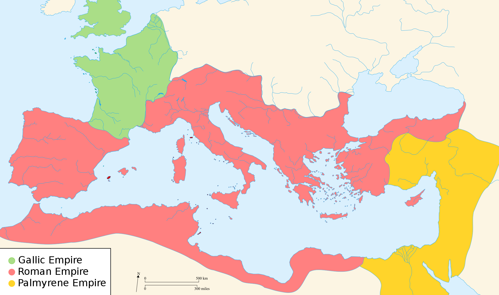
English: Map of the Roman Empire around the year of the consulship of Aurelianus and Bassus (271 AD), with the break away Gallic Empire in the West and the Palmyrene Empire in the East. |
||
| تاریخ | (UTC) | ||
| ماخذ | |||
| مصنف |
|
||
| اجازت (فائل کا دوبارہ استعمال) |
میں اس کام کا کاپی رائٹ ہولڈر ہوں اور اسے مندرجہ ذیل اجازت ناموں کے تحت شائع کیا ہے:
This file is licensed under the Creative Commons Attribution-Share Alike 2.5 Generic, 2.0 Generic and 1.0 Generic license.
آپ حسب منشا اجازت نامہ منتخب کر سکتے ہیں۔ |
||
| دوسرے نسخے |
[]
|


.svg)


|
یہ ایس وی جی (SVG) فائل نصب شدہ متن (ایمبیڈڈ ٹیکسٹ) پر مشتمل ہے، جسے کسی بھی SVG ایڈیٹر یا ٹیکسٹ ایڈیٹر کا استعمال کرتے ہوئے یا SVG آلہ ترجمہ کی معاونت سے آپ کی زبان میں ترجمہ کیا جا سکتا ہے۔ مزید معلومات کے لیے دیکھیے: SVG فائلوں کا ترجمہ۔ |
اجازہ کاری

|
آپ کو آزاد سافٹ ویئر فاؤنڈیشن کی جانب سے شائع کردہ جی این یو آزاد مسوداتی اجازت نامہ کی شرائط استعمال کے تحت اس دستاویز کو نقل، تقسیم اور/ یا ترمیم کرنے کی اجازت دی جاتی ہے۔ اس اجازت نامہ کی ایک نقل 'جی این یو آزاد مسوداتی اجازت نامہ کے عنوان سے میسر ہے۔ Subject to disclaimers. |
اولین اپلوڈ کا نوشتہ
- 2007-11-07 02:47 Justinian43 524×377×8 (26490 bytes) The Mediterranean by 271 A.D -The [[Roman Empire]]. -The breakaway [[Gallic Empire]]. -The breakaway [[Palmyrene Empire]].
- derivative work: Pomalee (talk)
other_versions=Derivative works of this file: Map of Ancient Rome 271 AD-sr.svg Permission= GNU Free Documentation License, Version 1.2, Creative Commons Attribution-ShareAlike license versions 3.0, 2.5, 2.0, and 1.0
- Romanworld271AD.jpg: User:Justinian43, uploaded by User:El_bes
| This is a retouched picture, which means that it has been digitally altered from its original version. Modifications: Used "Blank_map_of_South_Europe_and_North_Africa.svg" to refashion "Romanworld271.jpg". The original can be viewed here: Romanworld271AD.jpg:
|

|
آپ کو آزاد سافٹ ویئر فاؤنڈیشن کی جانب سے شائع کردہ جی این یو آزاد مسوداتی اجازت نامہ کی شرائط استعمال کے تحت اس دستاویز کو نقل، تقسیم اور/ یا ترمیم کرنے کی اجازت دی جاتی ہے۔ اس اجازت نامہ کی ایک نقل 'جی این یو آزاد مسوداتی اجازت نامہ کے عنوان سے میسر ہے۔ |
| اس ملف کا لائسنس Creative Commons Attribution-Share Alike 3.0 Unported کے تحط ہے۔ | ||
| ||
| This licensing tag was added to this file as part of the GFDL licensing update. |
اولین اپلوڈ کا نوشتہ
This image is a derivative work of the following images:
- File:Blank_map_of_South_Europe_and_North_Africa.svg licensed with Cc-by-sa-2.5,2.0,1.0, GFDL
- 2007-08-09T20:26:49Z Historicair 2050x1213 (1260388 Bytes)
- 2007-08-09T16:12:00Z Historicair 2050x1213 (351130 Bytes) {{Improving}} {{Information |Description={{fr}}Carte vierge de l'Europe du Sud et du Bassin Méditerranée dans l'Antiquité {{en}}Blank map of South Europe and North Africa at Antic period |Source=Own work + [[Image:Blank map of South Europe and North Africa.svg]] by myself
- File:Romanworld271AD.jpg licensed with GFDL-en
- 2007-11-20T15:23:56Z El bes 524x377 (26490 Bytes) {{Information |Description= The Roman Empire around the year 271 AD, with the break awai Gallic Empire in the West |Source= http://en.wikipedia.org/wiki/Image:Romanworld271AD.JPG |Date= November 20th, 2007 |Author= [[http://e
Uploaded with derivativeFX
فائل کا تاریخچہ
کسی خاص وقت یا تاریخ میں یہ فائل کیسی نظر آتی تھی، اسے دیکھنے کے لیے اس وقت/تاریخ پر کلک کریں۔
| تاریخ/وقت | تھمب نیل | ابعاد | صارف | تبصرہ | |
|---|---|---|---|---|---|
| رائج الوقت | 21:07، 20 مارچ 2022ء | | 2,050 × 1,213 (207 کلوبائٹ) | Leptictidium | File uploaded using svgtranslate tool (https://svgtranslate.toolforge.org/). Added translation for ca. |
| 05:06، 24 اگست 2018ء |  | 2,050 × 1,213 (207 کلوبائٹ) | Ras67 | frame removed | |
| 15:14، 18 دسمبر 2011ء |  | 2,050 × 1,213 (385 کلوبائٹ) | Wanwa | more pleasant for eyesight colors | |
| 21:39، 27 اگست 2010ء |  | 2,050 × 1,213 (384 کلوبائٹ) | Cplakidas | Corrections: the Agri Decumates beyond the Rhine had been abandoned already in 263, the Provence and Spain had been recovered by Rome in 269, and in 271, Zenobia controlled Asia Minor as far as Ancara at least | |
| 05:30، 26 فروری 2009ء |  | 2,050 × 1,213 (396 کلوبائٹ) | Pomalee | Removed text labels from their paths and created a key. | |
| 04:36، 26 فروری 2009ء |  | 2,050 × 1,213 (393 کلوبائٹ) | Pomalee | Changed the "Palmyran" label to "Palmyrene" | |
| 04:15، 26 فروری 2009ء |  | 2,050 × 1,213 (393 کلوبائٹ) | Pomalee | {{Information |Description={{en}}Map of the Roman Empire around the year 271 AD, with the break away Gallic Empire in the West and the Palmyric Empire in the East. |Source=*File:Map_of_the_Ancient_Rome_at_Caesar_time-fr.svg *[[:File:Romanworld271AD. |
روابط
درج ذیل صفحہ اس فائل کو استعمال کر رہا ہے:
فائل کا عالمی استعمال
مندرجہ ذیل ویکیوں میں یہ فائل زیر استعمال ہے:
- af.wikipedia.org پر استعمال
- als.wikipedia.org پر استعمال
- ar.wikipedia.org پر استعمال
- azb.wikipedia.org پر استعمال
- az.wikipedia.org پر استعمال
- be-tarask.wikipedia.org پر استعمال
- be.wikipedia.org پر استعمال
- ca.wikipedia.org پر استعمال
- cs.wikipedia.org پر استعمال
- cy.wikipedia.org پر استعمال
- de.wikipedia.org پر استعمال
- el.wikipedia.org پر استعمال
- en.wikipedia.org پر استعمال
- 271
- Aurelian
- Claudius Gothicus
- Crisis of the Third Century
- Outline of ancient Rome
- Western Roman Empire
- Tetricus I
- Ancient Rome
- Late Latin
- Fall of the Western Roman Empire
- List of revolutions and rebellions
- Ledringhem
- List of Roman external wars and battles
- User:ChazCAESAR/sandbox
- User:Kazkaskazkasako/Books/History
- Classical Anatolia
اس فائل کا مزید عالمی استعمال دیکھیے۔