فائل:MapaMacau1912.jpg
اس نمائش کا حجم: 416 × 599 پکسلز۔ دیگر تصمیمات: 167 × 240 پکسلز | 631 × 908 پکسلز۔
اصل فائل (631 × 908 پکسل، فائل کا حجم: 81 کلوبائٹ، MIME قسم: image/jpeg)
خلاصہ
| تفصیل |
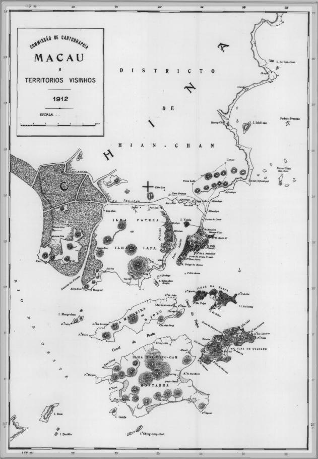
English: This is a map of Macau and is surrounded territories in 1912. In that time, the Portuguese Colony of Macau is formed by the Peninsula de Macau, Taipa and Coloane islands. Macau also have a great influence on the islands of Lapa, D. João and Montanha, located on the west of the Portuguese Colony of Macau. See here for original color version. |
| تاریخ | |
| ماخذ | |
| مصنف |
اجازہ کاری
This work is from an official work of Macau and is in the public domain in Macau and possibly other jurisdictions. See here for the type of material that are in the Public domain in Chinese and Portuguese (official languages of Macau), plus English (not an official language of Macau).
|
 | |
| Annotations | This image is annotated: View the annotations at Commons |
فائل کا تاریخچہ
کسی خاص وقت یا تاریخ میں یہ فائل کیسی نظر آتی تھی، اسے دیکھنے کے لیے اس وقت/تاریخ پر کلک کریں۔
| تاریخ/وقت | تھمب نیل | ابعاد | صارف | تبصرہ | |
|---|---|---|---|---|---|
| رائج الوقت | 09:34، 14 فروری 2007ء | | 631 × 908 (81 کلوبائٹ) | AdriAg | This is a map of Macau and is surrounded territories in 1912. In that time, the Portuguese Colony of Macau is formed by the [http://pt.wikipedia.org/wiki/Pen%C3%ADnsula_de_Macau Peninsula de Macau], [http://pt.wikipedia.org/wiki/Taipa Taipa] and [http://p |
روابط
درج ذیل صفحہ اس فائل کو استعمال کر رہا ہے:
فائل کا عالمی استعمال
مندرجہ ذیل ویکیوں میں یہ فائل زیر استعمال ہے:
- en.wikipedia.org پر استعمال
- es.wikipedia.org پر استعمال
- fa.wikipedia.org پر استعمال
- fr.wikipedia.org پر استعمال
- it.wikipedia.org پر استعمال
- ja.wikipedia.org پر استعمال
- mwl.wikipedia.org پر استعمال
- nl.wikipedia.org پر استعمال
- no.wikipedia.org پر استعمال
- pt.wikipedia.org پر استعمال
- ru.wikipedia.org پر استعمال
- zh.wikipedia.org پر استعمال