فائل:National Highway 2 (India).png

اس نمائش کا حجم: 800 × 481 پکسلز۔ دیگر تصمیمات: 320 × 192 پکسلز | 640 × 385 پکسلز | 1,222 × 735 پکسلز۔
اصل فائل (1,222 × 735 پکسل، فائل کا حجم: 700 کلوبائٹ، MIME قسم: image/png)
.png)
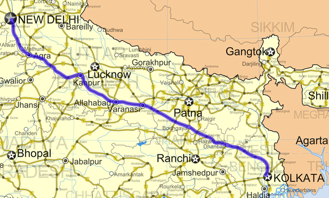
| تفصیل | National Highway 2 in India |
| تاریخ | (UTC) |
| ماخذ | |
| مصنف |
|
| This is a retouched picture, which means that it has been digitally altered from its original version. The original can be viewed here: India roadway map.svg:
|
میں اس تخلیقی کام کے حقوق کا مالک ہوں اور اسے مندرجہ ذیل اجازت نامے کے تحت شائع کرتا ہوں:
اس ملف کا لائسنس Creative Commons Attribution-Share Alike 3.0 Unported کے تحط ہے۔
- آپ آزاد ہیں:
- شیئر کرنے – کام کو نقل، تقسیم یا منتقل کرنے کے لیے
- ریمکس کے لیے – کام منبطق کرنے کے لیے
- مندرجہ ذیل شرائط کے تحت:
- انتساب – آپ کو اس کام کا انتساب مصنف یا اجازت دہندہ کے بتائے گئے طریقہ کے مطابق دینا ہوگا (تاہم یہ انتساب اس طرح نہیں ہونا چاہیے کہ اسے دیکھ کر ایسا محسوس ہو کہ اصل مصنف یا اجازت دہندہ آپ کے یا آپ کے ذریعہ اس کام کے استعمال کرنے کے حامی ہیں)۔
- یکساں شراکت – اگر آپ اس کام میں کوئی تبدیلی یا ترمیم کرتے ہیں یا اس کام پر مبنی کچھ نیا بناتے ہیں تو اسے بھی آپ اسی یا اس جیسے کسی اجازت نامے کے تحت شائع کر سکتے ہیں۔
اولین اپلوڈ کا نوشتہ
This image is a derivative work of the following images:
- File:India_roadway_map.svg licensed with Cc-by-sa-3.0
- 2007-04-02T06:14:09Z Gmaxwell 1639x1852 (931168 Bytes) Please do not include copyrighted fonts in your SVGs.
- 2007-04-02T06:13:22Z Gmaxwell 1639x1852 (931168 Bytes) Please do not include copyrighted fonts in your SVGs.
- 2007-01-09T07:33:51Z PlaneMad 1639x1852 (1025350 Bytes) uttaranchal>uttarkhand, minor color corrections and numbering correction
- 2006-11-13T17:04:31Z PlaneMad 1639x1852 (1042154 Bytes) designation for all highways
- 2006-11-09T10:59:17Z PlaneMad 1639x1852 (885509 Bytes) updated karnataka city spellings, added nh 110 112 113 114 116 117 119 121 123 153 154 155 224 225 226 227, corrections in north east states
- 2006-11-06T19:31:09Z PlaneMad 1639x1852 (864712 Bytes) nh designation markers on nhdp highways, rivers enabled, lightened state names, 3d locators for capitals and major cities, minor corrections north east areas
- 2006-10-15T18:01:16Z PlaneMad 1639x1852 (734840 Bytes) Included Nhdp phase IIIA, Changed stroke styles for highways, changed marker locators, added state names, included road legend, added more cities and towns, corrections
- 2006-08-01T18:38:00Z PlaneMad 1639x1852 (619927 Bytes) 100% highway coverage, more towns added, route corrections
- 2006-06-28T18:37:38Z PlaneMad 1639x1852 (1103121 Bytes) added cities and towns throughout india, all rivers added
- 2006-06-27T19:33:15Z PlaneMad 1639x1852 (953120 Bytes) first upload, includes 59000+ km of national highways + NHDP phase I II
Uploaded with derivativeFX
فائل کا تاریخچہ
کسی خاص وقت یا تاریخ میں یہ فائل کیسی نظر آتی تھی، اسے دیکھنے کے لیے اس وقت/تاریخ پر کلک کریں۔
| تاریخ/وقت | تھمب نیل | ابعاد | صارف | تبصرہ | |
|---|---|---|---|---|---|
| رائج الوقت | 03:14، 31 مئی 2009ء | | 1,222 × 735 (700 کلوبائٹ) | Abhijitsathe | Higher resolution |
| 02:46، 2 اپریل 2009ء |  | 750 × 426 (319 کلوبائٹ) | Abhijitsathe | {{Information |Description=National Highway 2 in India |Source=*File:India_roadway_map.svg |Date=2009-04-02 03:45 (UTC) |Author=*File:India_roadway_map.svg: '''Cc-by-sa-3.0''' *derivative work: ~~~ |Permission=see below |other_versions= }} {{ |
روابط
درج ذیل صفحہ اس فائل کو استعمال کر رہا ہے:
فائل کا عالمی استعمال
مندرجہ ذیل ویکیوں میں یہ فائل زیر استعمال ہے:
- de.wikipedia.org پر استعمال
- en.wikipedia.org پر استعمال
- gu.wikipedia.org پر استعمال
- ml.wikipedia.org پر استعمال
- mr.wikipedia.org پر استعمال
- or.wikipedia.org پر استعمال
- pnb.wikipedia.org پر استعمال
- ta.wikipedia.org پر استعمال
- te.wikipedia.org پر استعمال
- www.wikidata.org پر استعمال
- zh.wikipedia.org پر استعمال
.png)