فائل:New 2000 black density.gif

اس نمائش کا حجم: 776 × 600 پکسلز۔ دیگر تصمیمات: 311 × 240 پکسلز | 621 × 480 پکسلز | 994 × 768 پکسلز | 1,280 × 989 پکسلز | 2,604 × 2,012 پکسلز۔
اصل فائل (2,604 × 2,012 پکسل، فائل کا حجم: 620 کلوبائٹ، MIME قسم: image/gif)

|
This ethnographic map image could be re-created using vector graphics as an SVG file. This has several advantages; see Commons:Media for cleanup for more information. If an SVG form of this image is available, please upload it and afterwards replace this template with
{{vector version available|new image name}}.
It is recommended to name the SVG file “New 2000 black density.svg”—then the template Vector version available (or Vva) does not need the new image name parameter. |
خلاصہ
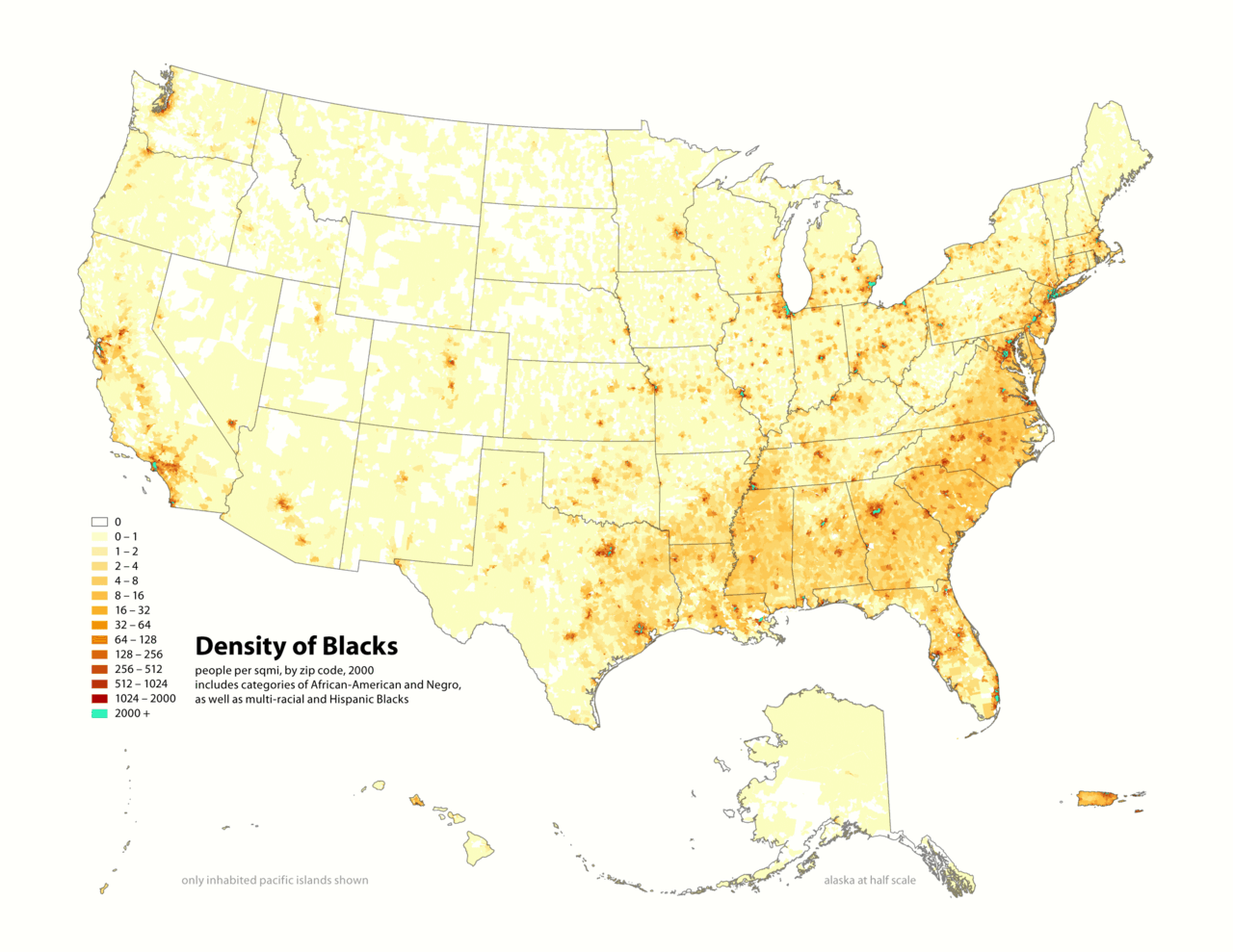
Map of contiguous US, showing density of self-reported "Black" population, in persons per square mile, by census tract, 2000. Data source: US Census.
I (user:Citynoice) am the designer and creator of this map and license it under the Creative Commons Attribution ShareAlike 2.5 License.
similar maps:
- w:Image:New 2000 asian density.gif
- w:Image:New 2000 asian percent.gif
- w:Image:New 2000 black density.gif
- w:Image:New 2000 black percent.gif
- w:Image:New 2000 hawaiian density.gif
- w:Image:New 2000 hawaiian percent.gif
- w:Image:New 2000 hispanic density.gif
- w:Image:New 2000 hispanic percent.gif
- w:Image:New 2000 indian density.gif
- w:Image:New 2000 indian percent.gif
- w:Image:New 2000 white density.gif
- w:Image:New 2000 white percent.gif
اجازہ کاری
This file is licensed under the Creative Commons Attribution-Share Alike 2.5 Generic license.
- آپ آزاد ہیں:
- شیئر کرنے – کام کو نقل، تقسیم یا منتقل کرنے کے لیے
- ریمکس کے لیے – کام منبطق کرنے کے لیے
- مندرجہ ذیل شرائط کے تحت:
- انتساب – آپ کو اس کام کا انتساب مصنف یا اجازت دہندہ کے بتائے گئے طریقہ کے مطابق دینا ہوگا (تاہم یہ انتساب اس طرح نہیں ہونا چاہیے کہ اسے دیکھ کر ایسا محسوس ہو کہ اصل مصنف یا اجازت دہندہ آپ کے یا آپ کے ذریعہ اس کام کے استعمال کرنے کے حامی ہیں)۔
- یکساں شراکت – اگر آپ اس کام میں کوئی تبدیلی یا ترمیم کرتے ہیں یا اس کام پر مبنی کچھ نیا بناتے ہیں تو اسے بھی آپ اسی یا اس جیسے کسی اجازت نامے کے تحت شائع کر سکتے ہیں۔
فائل کا تاریخچہ
کسی خاص وقت یا تاریخ میں یہ فائل کیسی نظر آتی تھی، اسے دیکھنے کے لیے اس وقت/تاریخ پر کلک کریں۔
| تاریخ/وقت | تھمب نیل | ابعاد | صارف | تبصرہ | |
|---|---|---|---|---|---|
| رائج الوقت | 19:14، 1 مئی 2010ء | | 2,604 × 2,012 (620 کلوبائٹ) | Citynoise | Added Alaska, Hawaii, and Territories. Also changed from tracts to zip codes. |
| 13:40، 25 ستمبر 2006ء |  | 1,012 × 691 (99 کلوبائٹ) | CyberAngel | == Dettagli == {{Information| |Description={{en}} '''w:Republic of the New Afrika''' (RNA). Map of contiguous US, showing density of self-reported "Black" population, in persons per square mile, by census tract, 2000. ''Data source:'' US Census. {{it} |
روابط
درج ذیل صفحہ اس فائل کو استعمال کر رہا ہے:
فائل کا عالمی استعمال
مندرجہ ذیل ویکیوں میں یہ فائل زیر استعمال ہے:
- de.wikiversity.org پر استعمال
- en.wikipedia.org پر استعمال
- fa.wikipedia.org پر استعمال
- fr.wikipedia.org پر استعمال
- gl.wikipedia.org پر استعمال
- it.wikipedia.org پر استعمال
- ja.wikipedia.org پر استعمال
- nl.wikipedia.org پر استعمال
- pl.wikipedia.org پر استعمال
- pt.wikipedia.org پر استعمال
- tl.wikipedia.org پر استعمال