فائل:Rail gauge world.svg

اس SVG فائل کی PNG نمائش کا حجم: 800 × 406 پکسلز دیگر تصمیمات: 320 × 162 پکسلز | 640 × 325 پکسلز | 1,024 × 520 پکسلز | 1,280 × 650 پکسلز | 2,560 × 1,300 پکسلز | 2,754 × 1,398 پکسلز۔
اصل فائل (ایس وی جی فائل، ابعاد 2,754 × 1,398 پکسل، فائل کا حجم: 1.05 MB)
خلاصہ
| وضاحت |
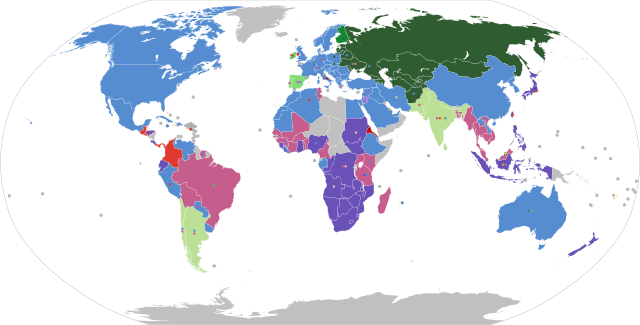
English: Shows the railroad gauge which is currently most used in each country (main colour), with other significant gauges used depicted as small squares on top of the main colour. Grey indicates no railways.
Español: Muestra el ancho de vía más comunmente usado en cada país (color principal), con otros anchos representados con pequeños cuadrados sobre el color principal. El color gris indica que no existen vías férreas en el territorio.
Français : Montre l'écartement le plus utilisé dans chaque pays (couleur principale), les autres écartements significatifs sont illustrés par des petits carrés superposés sur la couleur principale. Le gris indique l'absence de chemins de fer.
Русский: Ширина колеи железных дорог, используемая в настоящее время наиболее часто в разных странах (основной цвет). Прочие используемые ширины колеи изображены в виде маленьких квадратиков поверх основного цвета. Серый цвет — отсутствие железных дорог.
中文:图中各国的主色表示该国最通用的铁路轨距,小色块代表其他重要的轨距,灰色则为尚无铁路的国家 |
| Map legend |
597 mm, 600 mm, 603 mm, 610 mm (Two foot)
750 mm, 760 mm Bosnian, 762 mm (Two foot six inch), 800 mm
891 mm Swedish, 900 mm, 914 mm (Three foot)
1000 mm (Metre)
1067 mm (Three foot six inch)
1372 mm (Four foot six inch)
1435 mm Standard
1520 mm Russian standard
1524 mm Old Russian standard (Five foot)
1600 mm (Five foot three inch)
1668 mm Iberian
1676 mm Indian (Five foot six inch)
1829 mm (Six foot), 2140 mm Brunel |
| SVG genesis | |
| تاریخ | |
| ماخذ | Made using the list on CIA Factbook railways, Seabhcan's railmap and OpenRailwayMap. Uses BlankMap-World.svg |
| خالق |
selfmade |
| Georeferencing | If inappropriate please set warp_status = skip to hide. |
| دوسرے نسخے | PNG version (outdated), SVG version with legend (current) |


اجازہ کاری
میں اس تخلیقی کام کے حقوق کا مالک ہوں اور اسے مندرجہ ذیل اجازت نامے کے تحت شائع کرتا ہوں:

|
آپ کو آزاد سافٹ ویئر فاؤنڈیشن کی جانب سے شائع کردہ جی این یو آزاد مسوداتی اجازت نامہ کی شرائط استعمال کے تحت اس دستاویز کو نقل، تقسیم اور/ یا ترمیم کرنے کی اجازت دی جاتی ہے۔ اس اجازت نامہ کی ایک نقل 'جی این یو آزاد مسوداتی اجازت نامہ کے عنوان سے میسر ہے۔ |
| اس ملف کا لائسنس Creative Commons Attribution-Share Alike 3.0 Unported کے تحط ہے۔ | ||
| ||
| This licensing tag was added to this file as part of the GFDL licensing update. |
فائل کا تاریخچہ
کسی خاص وقت یا تاریخ میں یہ فائل کیسی نظر آتی تھی، اسے دیکھنے کے لیے اس وقت/تاریخ پر کلک کریں۔
| تاریخ/وقت | تھمب نیل | ابعاد | صارف | تبصرہ | |
|---|---|---|---|---|---|
| رائج الوقت | 22:55، 19 جنوری 2024ء | | 2,754 × 1,398 (1.05 MB) | Rtfroot | Mauritius metro (1435mm), Indonesia high speed line (1435mm) |
| 22:53، 18 نومبر 2023ء |  | 2,754 × 1,398 (1.05 MB) | Akeosnhaoe | Sakhalin | |
| 10:02، 25 ستمبر 2023ء |  | 2,754 × 1,398 (1.05 MB) | Akeosnhaoe | Tunisia | |
| 14:00، 16 جولائی 2023ء |  | 2,754 × 1,398 (1.05 MB) | Wikkiwonkk | added Cape gauge to Lesotho (small spur connecting to South Africa's network); removed Inkscape/Sodipodi cruft | |
| 03:50، 11 مارچ 2023ء |  | 2,754 × 1,398 (1.06 MB) | Wikkiwonkk | added standard gauge to Tanzania | |
| 03:46، 11 مارچ 2023ء |  | 2,754 × 1,398 (1.1 MB) | Wikkiwonkk | Reverted to version as of 18:14, 12 September 2022 (UTC) - svg2png tool doesn't work with CSS colours as variables! *cries* | |
| 03:43، 11 مارچ 2023ء |  | 2,754 × 1,398 (1.06 MB) | Wikkiwonkk | reverted the file structure back to the hand editable version, but incorporating the recent Tanzania change; changed all the colours to be named variables to make future edits easier | |
| 18:55، 8 مارچ 2023ء |  | 2,754 × 1,398 (3.39 MB) | Rtfroot | added Tanzania standard gauge (The first phase Dar es Salaam–Morogoro Section has been completed in April 2022 currently in live testing phase) | |
| 18:14، 12 ستمبر 2022ء |  | 2,754 × 1,398 (1.1 MB) | Delusion23 | Isle of Man railways are narrow gauge | |
| 20:10، 24 جولائی 2022ء |  | 2,754 × 1,398 (1.06 MB) | Виталий Болбас | Fixed Afghanistan |
روابط
درج ذیل صفحہ اس فائل کو استعمال کر رہا ہے:
فائل کا عالمی استعمال
مندرجہ ذیل ویکیوں میں یہ فائل زیر استعمال ہے:
- ar.wikipedia.org پر استعمال
- bn.wikipedia.org پر استعمال
- en.wikipedia.org پر استعمال
- Narrow-gauge railway
- Network effect
- Standard-gauge railway
- Broad-gauge railway
- Great Western Railway
- Track gauge
- Railway track
- European integration
- Metre-gauge railway
- Bering Strait crossing
- Break of gauge
- Rail freight transport
- 3 ft 6 in gauge railways
- Talk:San Diego Electric Railway
- Ten and a quarter inch gauge
- Minimum-gauge railway
- Baltimore Streetcar Museum
- 5 ft and 1520 mm gauge railways
- Variable gauge
- Template:Track gauge sidebar
- Decauville
- List of track gauges
- 4 ft 6 in gauge railway
- Narrow-gauge railways in Canada
- Narrow-gauge railroads in the United States
- Bogie exchange
- Track gauge conversion
- List of 2 ft 3 in gauge railways
- Track gauge in Ireland
- 5 ft 3 in gauge railways
- 5 ft 6 in gauge railway
- Iberian-gauge railways
- Track gauge in Canada
- Track gauge in South America
- Track gauge in Europe
- List of gauge conversions
- Track gauge in North America
- Trams in Dresden
- Trams in Leipzig
- Bosnian-gauge railways
- Track gauge in Italy
- Fifteen-inch gauge railway
اس فائل کا مزید عالمی استعمال دیکھیے۔