فائل:Rajputana States - Census of India 1891.jpg

اس نمائش کا حجم: 386 × 599 پکسلز۔ دیگر تصمیمات: 154 × 240 پکسلز | 309 × 480 پکسلز | 495 × 768 پکسلز | 660 × 1,024 پکسلز | 1,450 × 2,250 پکسلز۔
اصل فائل (1,450 × 2,250 پکسل، فائل کا حجم: 189 کلوبائٹ، MIME قسم: image/jpeg)
خلاصہ
| تفصیل |
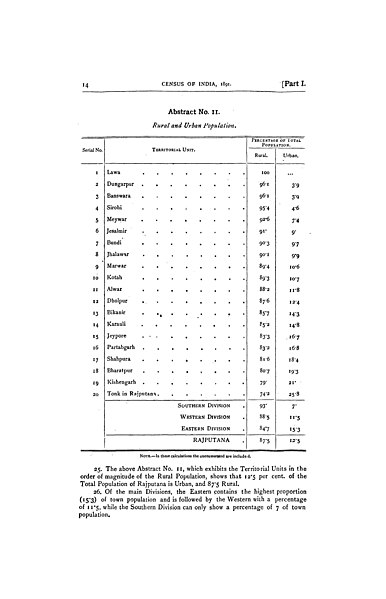
English: Image shows the page listing of 20 princely states of Rajputana in 1891. The 1891 Census of India was conducted by the British Raj and covered the lands now part of India, Pakistan, Bangladesh and Burma. The Census Commissioner was Jervoise Athelstane Baines, who was later knighted for his work in India. |
| تاریخ | |
| ماخذ | https://archive.org/details/dli.granth.112411/page/14/mode/2up?view=theater |
| مصنف |
The 1891 Census of India was conducted by the British Raj and covered the lands now part of India, Pakistan, Bangladesh and Burma. The Census Commissioner was Jervoise Athelstane Baines, who was later knighted for his work in India. Above picture shows the page which contains the population distribution of 20 territorial units of Rajputana Agency of British times. Lawa State was the smallest independent state. |
اجازہ کاری
This file is licensed under the Creative Commons Attribution-Share Alike 4.0 International license.
- آپ آزاد ہیں:
- شیئر کرنے – کام کو نقل، تقسیم یا منتقل کرنے کے لیے
- ریمکس کے لیے – کام منبطق کرنے کے لیے
- مندرجہ ذیل شرائط کے تحت:
- انتساب – آپ کو اس کام کا انتساب مصنف یا اجازت دہندہ کے بتائے گئے طریقہ کے مطابق دینا ہوگا (تاہم یہ انتساب اس طرح نہیں ہونا چاہیے کہ اسے دیکھ کر ایسا محسوس ہو کہ اصل مصنف یا اجازت دہندہ آپ کے یا آپ کے ذریعہ اس کام کے استعمال کرنے کے حامی ہیں)۔
- یکساں شراکت – اگر آپ اس کام میں کوئی تبدیلی یا ترمیم کرتے ہیں یا اس کام پر مبنی کچھ نیا بناتے ہیں تو اسے بھی آپ اسی یا اس جیسے کسی اجازت نامے کے تحت شائع کر سکتے ہیں۔
فائل کا تاریخچہ
کسی خاص وقت یا تاریخ میں یہ فائل کیسی نظر آتی تھی، اسے دیکھنے کے لیے اس وقت/تاریخ پر کلک کریں۔
| تاریخ/وقت | تھمب نیل | ابعاد | صارف | تبصرہ | |
|---|---|---|---|---|---|
| رائج الوقت | 20:43، 18 اکتوبر 2022ء | | 1,450 × 2,250 (189 کلوبائٹ) | Tpsn98290 | Uploaded a work by The 1891 Census of India was conducted by the British Raj and covered the lands now part of India, Pakistan, Bangladesh and Burma. The Census Commissioner was Jervoise Athelstane Baines, who was later knighted for his work in India. Above picture shows the page which contains the population distribution of 20 territorial units of Rajputana Agency of British times. Lawa State was the smallest independent state. from https://archive.org/details/dli.granth.112411/page/14/mode... |
روابط
درج ذیل صفحہ اس فائل کو استعمال کر رہا ہے:
فائل کا عالمی استعمال
مندرجہ ذیل ویکیوں میں یہ فائل زیر استعمال ہے:
- en.wikipedia.org پر استعمال