فائل:Stonehenge World Heritage Site map 2.svg

اس SVG فائل کی PNG نمائش کا حجم: 497 × 600 پکسلز دیگر تصمیمات: 199 × 240 پکسلز | 398 × 480 پکسلز | 636 × 768 پکسلز | 848 × 1,024 پکسلز | 1,696 × 2,048 پکسلز | 1,438 × 1,736 پکسلز۔
اصل فائل (ایس وی جی فائل، ابعاد 1,438 × 1,736 پکسل، فائل کا حجم: 1.57 MB)
خلاصہ
| تفصیل |
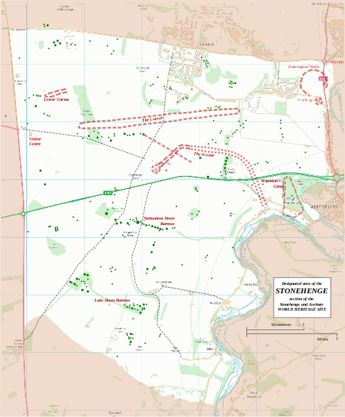
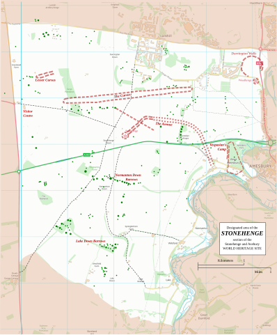
English: Boundary and key sites on the Avebury section of the Stonehenge, Avebury and Associated Sites World Heritage Site |
| تاریخ | |
| ماخذ | OS Open Data with additional material cited at World Heritage Site list No 373 |
| مصنف | RobinLeicester building on OS OpenData VextorMap District Raster files |
| Camera location | | View this and other nearby images on: OpenStreetMap |
|---|
Principal monuments and earthworks are shown in Red. Barrows are indicated by green dots.
اجازہ کاری
This file is licensed by the Ordnance Survey of the United Kingdom under their OS OpenData License
In short: you are free to distribute and modify the file as long as you attribute (including year), the Ordnance Survey. لگاؤ: Contains Ordnance Survey data © Crown copyright and database right (year) Note: Derivative works can be licensed under any Creative Commons Attribution 3.0 Licence. |
_(St_Edwards_Crown).svg)
|
This file is licensed under the United Kingdom Open Government Licence v3.0. |
See also: Meta for information on usage on Wikimedia wikis.
|
فائل کا تاریخچہ
کسی خاص وقت یا تاریخ میں یہ فائل کیسی نظر آتی تھی، اسے دیکھنے کے لیے اس وقت/تاریخ پر کلک کریں۔
| تاریخ/وقت | تھمب نیل | ابعاد | صارف | تبصرہ | |
|---|---|---|---|---|---|
| رائج الوقت | 22:36، 13 جنوری 2015ء | | 1,438 × 1,736 (1.57 MB) | RobinLeicester | User created page with UploadWizard |
روابط
درج ذیل صفحہ اس فائل کو استعمال کر رہا ہے:
فائل کا عالمی استعمال
مندرجہ ذیل ویکیوں میں یہ فائل زیر استعمال ہے:
- cs.wikipedia.org پر استعمال
- de.wikipedia.org پر استعمال
- en.wikipedia.org پر استعمال
- fi.wikipedia.org پر استعمال
- fr.wikipedia.org پر استعمال
- fr.wikivoyage.org پر استعمال
- ja.wikipedia.org پر استعمال
- kw.wikipedia.org پر استعمال
- nl.wikipedia.org پر استعمال
- ru.wikipedia.org پر استعمال
- simple.wikipedia.org پر استعمال
- sl.wikipedia.org پر استعمال
- zh.wikipedia.org پر استعمال