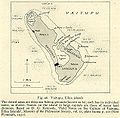
فائل:Vaitupu ellice islands.jpg

اس نمائش کا حجم: 610 × 599 پکسلز۔ دیگر تصمیمات: 244 × 240 پکسلز | 636 × 625 پکسلز۔
اصل فائل (636 × 625 پکسل، فائل کا حجم: 141 کلوبائٹ، MIME قسم: image/jpeg)
فائل کا تاریخچہ
کسی خاص وقت یا تاریخ میں یہ فائل کیسی نظر آتی تھی، اسے دیکھنے کے لیے اس وقت/تاریخ پر کلک کریں۔
| تاریخ/وقت | تھمب نیل | ابعاد | صارف | تبصرہ | |
|---|---|---|---|---|---|
| رائج الوقت | 17:40، 11 نومبر 2006ء |  | 636 × 625 (141 کلوبائٹ) | Ratzer |
روابط
درج ذیل صفحہ اس فائل کو استعمال کر رہا ہے:
فائل کا عالمی استعمال
مندرجہ ذیل ویکیوں میں یہ فائل زیر استعمال ہے:
- ast.wikipedia.org پر استعمال
- ca.wikipedia.org پر استعمال
- cs.wikipedia.org پر استعمال
- de.wikipedia.org پر استعمال
- en.wikipedia.org پر استعمال
- eo.wikipedia.org پر استعمال
- fa.wikipedia.org پر استعمال
- fr.wikipedia.org پر استعمال
- gl.wikipedia.org پر استعمال
- incubator.wikimedia.org پر استعمال
- ja.wikipedia.org پر استعمال
- ko.wikipedia.org پر استعمال
- lt.wikipedia.org پر استعمال
- mk.wikipedia.org پر استعمال
- nl.wikipedia.org پر استعمال
- no.wikipedia.org پر استعمال
- pl.wikipedia.org پر استعمال
- pt.wikipedia.org پر استعمال
- ro.wikipedia.org پر استعمال
- ru.wikipedia.org پر استعمال
- uk.wikipedia.org پر استعمال
- www.wikidata.org پر استعمال
- zh.wikipedia.org پر استعمال