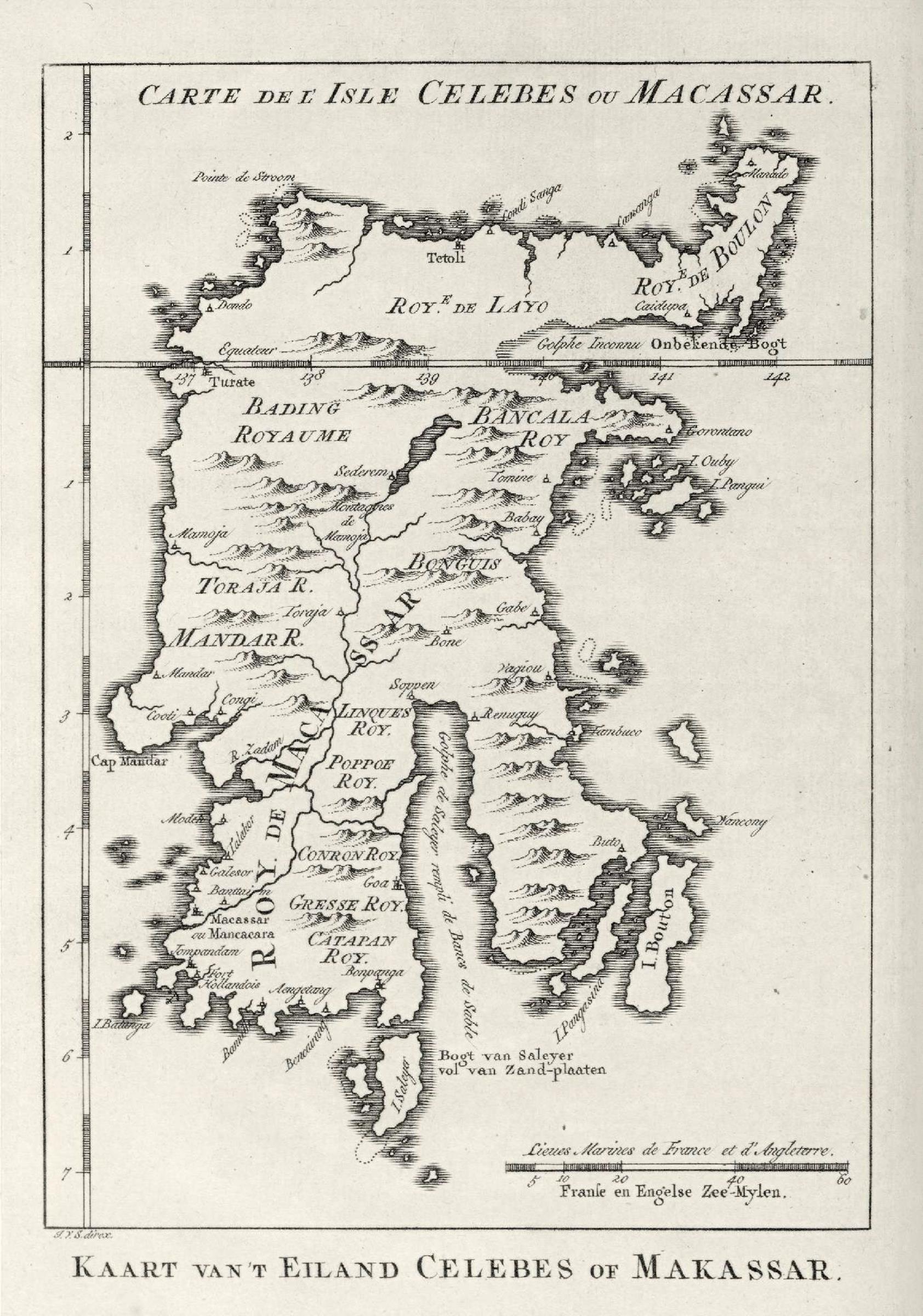
فائل:AMH-8027-KB Map of Celebes.jpg
اس نمائش کا حجم: 421 × 600 پکسلز۔ دیگر تصمیمات: 168 × 240 پکسلز | 337 × 480 پکسلز | 539 × 768 پکسلز | 718 × 1,024 پکسلز | 1,684 × 2,400 پکسلز۔
اصل فائل (1,684 × 2,400 پکسل، فائل کا حجم: 609 کلوبائٹ، MIME قسم: image/jpeg)
خلاصہ
Nederlands: Kaart van Celebes
English: Map of Celebes( |
|||||||||||||||||||||||||||||||||||||||||||||
|---|---|---|---|---|---|---|---|---|---|---|---|---|---|---|---|---|---|---|---|---|---|---|---|---|---|---|---|---|---|---|---|---|---|---|---|---|---|---|---|---|---|---|---|---|---|
| مصنف |
Nederlands: Pierre d' Hondt (uitgever), Jacobus van der Schley (direxit)
English: Pierre d' Hondt (publisher), Jacobus van der Schley (direxit) |
||||||||||||||||||||||||||||||||||||||||||||
| عنوان |
Nederlands: Kaart van Celebes
English: Map of Celebes |
||||||||||||||||||||||||||||||||||||||||||||
| تفصیل |
Nederlands: Kaart van Celebes.
Carte de l' Isle Celebes ou Macassar. Kaart van 't Eiland Celebes of Makassar.English: Map of Celebes.
Carte de l' Isle Celebes ou Macassar. Kaart van 't Eiland Celebes of Makassar. |
||||||||||||||||||||||||||||||||||||||||||||
| تاریخ | 1757 | ||||||||||||||||||||||||||||||||||||||||||||
| وسیلۂ تخلیق |
Nederlands: gravure op papier
English: engraving on paper |
||||||||||||||||||||||||||||||||||||||||||||
| ابعاد | اونچائی: 11.5 cm؛ اونچائی: 16.5 cm | ||||||||||||||||||||||||||||||||||||||||||||
| مجموعہ |
|
||||||||||||||||||||||||||||||||||||||||||||
| اضافہ نمبر |
693 C 6 dl XV, to. p. 87 |
||||||||||||||||||||||||||||||||||||||||||||
| نقوش |
Carte de l' Isle Celebes ou Macassar / Kaart van 't Eiland Celebes of Makassar
author: J.V.S. direx. |
||||||||||||||||||||||||||||||||||||||||||||
| ملاحظات |
English: Subjects: chart / map / plan
Nederlands: Onderwerpen: plattegrond / kaart
English: Post: this image is related to a VOC trading post called Tolitoli |
||||||||||||||||||||||||||||||||||||||||||||
| ماخذ/مصور |
|
||||||||||||||||||||||||||||||||||||||||||||
| اجازت (فائل کا دوبارہ استعمال) |
|
||||||||||||||||||||||||||||||||||||||||||||

| Object location | | View this and other nearby images on: OpenStreetMap |
|---|
فائل کا تاریخچہ
کسی خاص وقت یا تاریخ میں یہ فائل کیسی نظر آتی تھی، اسے دیکھنے کے لیے اس وقت/تاریخ پر کلک کریں۔
| تاریخ/وقت | تھمب نیل | ابعاد | صارف | تبصرہ | |
|---|---|---|---|---|---|
| رائج الوقت | 15:09، 10 جون 2014ء | | 1,684 × 2,400 (609 کلوبائٹ) | HuskyBot | == {{int:filedesc}} == {{Artwork |title = {{nl|1=Kaart van Celebes}} {{en|1=Map of Celebes}} |description = {{nl|1=Kaart van Celebes. ''Carte de l' Isle Celebes ou Macassar''. ''Kaart van 't Eiland Celebes of... |
روابط
درج ذیل صفحہ اس فائل کو استعمال کر رہا ہے:
فائل کا عالمی استعمال
مندرجہ ذیل ویکیوں میں یہ فائل زیر استعمال ہے:
- en.wikipedia.org پر استعمال
- nl.wikipedia.org پر استعمال
- uk.wikipedia.org پر استعمال
- zh.wikipedia.org پر استعمال