فائل:Bikini 2244493428 13643c6505 o.jpg

اس نمائش کا حجم: 800 × 583 پکسلز۔ دیگر تصمیمات: 320 × 233 پکسلز | 640 × 467 پکسلز | 1,024 × 747 پکسلز | 1,240 × 904 پکسلز۔
اصل فائل (1,240 × 904 پکسل، فائل کا حجم: 252 کلوبائٹ، MIME قسم: image/jpeg)

|
This map image could be re-created using vector graphics as an SVG file. This has several advantages; see Commons:Media for cleanup for more information. If an SVG form of this image is available, please upload it and afterwards replace this template with
{{vector version available|new image name}}.
It is recommended to name the SVG file “Bikini 2244493428 13643c6505 o.svg”—then the template Vector version available (or Vva) does not need the new image name parameter. |


خلاصہ
| تفصیل |
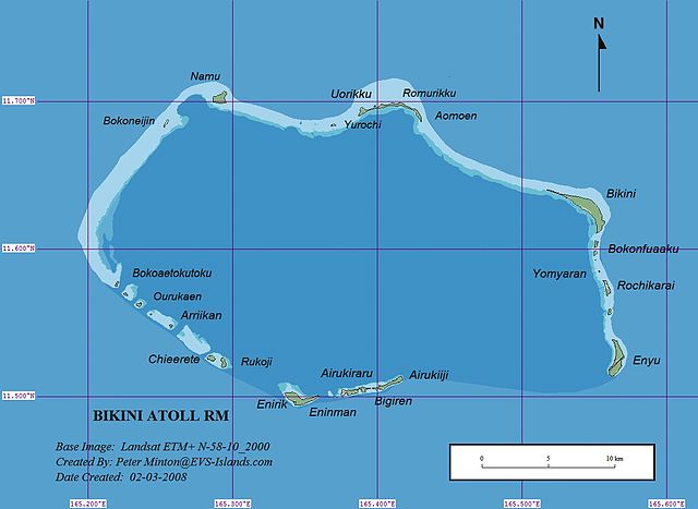
English: Map of Bikini Atoll, Ralik Chain, Marshall Islands, Pacific Ocean |
| تاریخ | |
| ماخذ | flickr |
| مصنف | Peter Minton (EVS Island) |
اجازہ کاری
This file is licensed under the Creative Commons Attribution 2.0 Generic license.
- آپ آزاد ہیں:
- شیئر کرنے – کام کو نقل، تقسیم یا منتقل کرنے کے لیے
- ریمکس کے لیے – کام منبطق کرنے کے لیے
- مندرجہ ذیل شرائط کے تحت:
- انتساب – آپ کو اس کام کا انتساب مصنف یا اجازت دہندہ کے بتائے گئے طریقہ کے مطابق دینا ہوگا (تاہم یہ انتساب اس طرح نہیں ہونا چاہیے کہ اسے دیکھ کر ایسا محسوس ہو کہ اصل مصنف یا اجازت دہندہ آپ کے یا آپ کے ذریعہ اس کام کے استعمال کرنے کے حامی ہیں)۔
| This image was originally posted to Flickr by EVS-Islands at https://www.flickr.com/photos/60042877@N00/2244493428. It was reviewed on 4 مارچ 2010 by FlickreviewR and was confirmed to be licensed under the terms of the cc-by-2.0. |
فائل کا تاریخچہ
کسی خاص وقت یا تاریخ میں یہ فائل کیسی نظر آتی تھی، اسے دیکھنے کے لیے اس وقت/تاریخ پر کلک کریں۔
| تاریخ/وقت | تھمب نیل | ابعاد | صارف | تبصرہ | |
|---|---|---|---|---|---|
| رائج الوقت | 07:46، 4 جولائی 2016ء | | 1,240 × 904 (252 کلوبائٹ) | NordNordWest | c |
| 22:32، 26 فروری 2010ء |  | 1,240 × 904 (214 کلوبائٹ) | Ratzer | {{Information |Description={{en|1=map of Bikini Atoll, Ralik Chain, Marshall Islands, Pacific Ocean}} |Source=http://www.flickr.com/photos/evsmap/2244493428/sizes/o/in/set-72157603853938862/ |Author=Peter Minton |Date=2008-03-02 |Permission= |other_versi |
روابط
درج ذیل صفحہ اس فائل کو استعمال کر رہا ہے:
فائل کا عالمی استعمال
مندرجہ ذیل ویکیوں میں یہ فائل زیر استعمال ہے:
- de.wikipedia.org پر استعمال
- en.wikipedia.org پر استعمال
- es.wikipedia.org پر استعمال
- et.wikipedia.org پر استعمال
- fa.wikipedia.org پر استعمال
- hr.wikipedia.org پر استعمال
- hu.wikipedia.org پر استعمال
- io.wikipedia.org پر استعمال
- it.wikipedia.org پر استعمال
- ko.wikipedia.org پر استعمال
- lb.wikipedia.org پر استعمال
- lv.wikipedia.org پر استعمال
- ms.wikipedia.org پر استعمال
- ne.wikipedia.org پر استعمال
- pl.wikipedia.org پر استعمال
- pt.wikipedia.org پر استعمال
- sh.wikipedia.org پر استعمال
- th.wikipedia.org پر استعمال
- vi.wikipedia.org پر استعمال
- war.wikipedia.org پر استعمال
- zh.wikipedia.org پر استعمال