فائل:Gulf of Honduras.jpg

اس نمائش کا حجم: 465 × 599 پکسلز۔ دیگر تصمیمات: 186 × 240 پکسلز | 372 × 480 پکسلز | 596 × 768 پکسلز | 795 × 1,024 پکسلز | 1,590 × 2,048 پکسلز | 2,602 × 3,352 پکسلز۔
اصل فائل (2,602 × 3,352 پکسل، فائل کا حجم: 1.71 MB، MIME قسم: image/jpeg)
خلاصہ
| تفصیل |
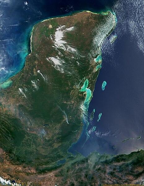
English: Yucatan Peninsula and Gulf of Honduras from MODIS - NASA Visible Earth. |
|||||
| تاریخ | ||||||
| ماخذ | http://visibleearth.nasa.gov/view.php?id=54567 | |||||
| مصنف | NASA | |||||
| اجازت (فائل کا دوبارہ استعمال) |
|
اجازہ کاری
| This file is in the public domain in the United States because it was solely created by NASA. NASA copyright policy states that "NASA material is not protected by copyright unless noted". (See Template:PD-USGov, NASA copyright policy page or JPL Image Use Policy.) | ||
 |
Warnings:
|
فائل کا تاریخچہ
کسی خاص وقت یا تاریخ میں یہ فائل کیسی نظر آتی تھی، اسے دیکھنے کے لیے اس وقت/تاریخ پر کلک کریں۔
| تاریخ/وقت | تھمب نیل | ابعاد | صارف | تبصرہ | |
|---|---|---|---|---|---|
| رائج الوقت | 06:05، 3 جنوری 2017ء | | 2,602 × 3,352 (1.71 MB) | Timothy Gu | Better resolution |
| 22:56، 23 فروری 2009ء |  | 1,302 × 1,677 (630 کلوبائٹ) | Arjuno3 | {{Information |Description={{en|1=Yucatan Peninsula and Gulf of Honduras from MODIS - NASA Visible Earth.}} |Source=http://veimages.gsfc.nasa.gov/292/MODIS1000085.jpg |Author=NASA |Date=2006-06-08 |Permission={{PD-USGov-NASA}} |other_versions= }} Gulf of |
روابط
درج ذیل 2 صفحات اس فائل کو استعمال کر رہے ہیں:
فائل کا عالمی استعمال
مندرجہ ذیل ویکیوں میں یہ فائل زیر استعمال ہے:
- ar.wikipedia.org پر استعمال
- be.wikipedia.org پر استعمال
- bg.wikipedia.org پر استعمال
- ca.wikipedia.org پر استعمال
- ceb.wikipedia.org پر استعمال
- cs.wikipedia.org پر استعمال
- en.wikipedia.org پر استعمال
- eo.wikipedia.org پر استعمال
- es.wikipedia.org پر استعمال
- eu.wikipedia.org پر استعمال
- gl.wikipedia.org پر استعمال
- he.wikipedia.org پر استعمال
- it.wikipedia.org پر استعمال
- ka.wikipedia.org پر استعمال
- ko.wikipedia.org پر استعمال
- lt.wikipedia.org پر استعمال
- ml.wikipedia.org پر استعمال
- mt.wikipedia.org پر استعمال
- nds.wikipedia.org پر استعمال
- nl.wikipedia.org پر استعمال
- nn.wikipedia.org پر استعمال
- no.wikipedia.org پر استعمال
- pl.wikipedia.org پر استعمال
- pl.wiktionary.org پر استعمال
- pnb.wikipedia.org پر استعمال
- ru.wikipedia.org پر استعمال
- simple.wikipedia.org پر استعمال
- sk.wikipedia.org پر استعمال
- sl.wikipedia.org پر استعمال
- sv.wikipedia.org پر استعمال
- th.wikipedia.org پر استعمال
- tr.wikipedia.org پر استعمال
- uk.wikipedia.org پر استعمال
اس فائل کا مزید عالمی استعمال دیکھیے۔