فائل:Kievan-rus-1015-1113-(en).png
اس نمائش کا حجم: 488 × 599 پکسلز۔ دیگر تصمیمات: 195 × 240 پکسلز | 391 × 480 پکسلز | 626 × 768 پکسلز | 834 × 1,024 پکسلز | 2,166 × 2,659 پکسلز۔
اصل فائل (2,166 × 2,659 پکسل، فائل کا حجم: 440 کلوبائٹ، MIME قسم: image/png)
خلاصہ
| تفصیل |
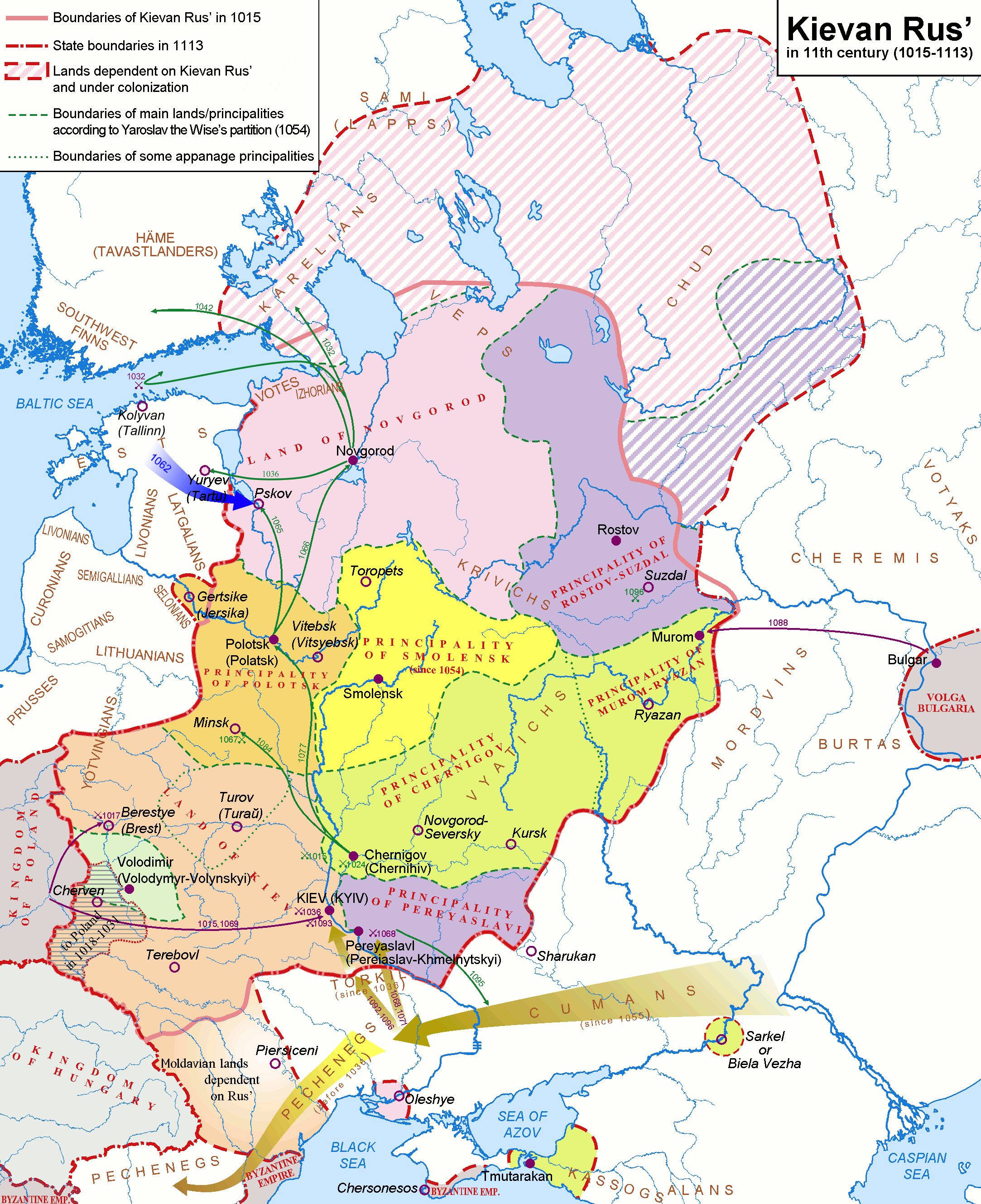
English: Map of the Kievan Rus' realm, 1015-1113 CE, of the medieval Rus' culture in Eastern Europe.
Deutsch: Karte - Das Kiewer Reich (»Kiewer Rus«) 1015-1113 (Englisch).
Русский: Карта — Киевская Русь в 1015-1113 гг. (по-Английски) |
| تاریخ | |
| ماخذ | http://commons.wikimedia.org/wiki/Image:Rus-1015-1113.png |
| مصنف |
Original version (russian): Koryakov Yuri English translation: Hellerick |
| دوسرے نسخے |
Rus-1015-1113.png:  Kievan-rus-1015-1113.png: Kievan-rus-1015-1113.png:  Kievan-rus-1015-1113-(de).png: Kievan-rus-1015-1113-(de).png: .png) Kievan-rus-1015-1113-(hu).svg: Kievan-rus-1015-1113-(hu).svg: .svg) |
.png)
.png)

|
Attribution information, such as the author's name, e-mail, website, or signature, that was once visible in the image itself has been moved into the image metadata and/or image description page. This makes the image easier to reuse and more language-neutral, and makes the text easier to process and search for. Commons discourages placing visible author information in images.
|

|
This map image could be re-created using vector graphics as an SVG file. This has several advantages; see Commons:Media for cleanup for more information. If an SVG form of this image is available, please upload it and afterwards replace this template with
{{vector version available|new image name}}.
It is recommended to name the SVG file “Kievan-rus-1015-1113-(en).svg”—then the template Vector version available (or Vva) does not need the new image name parameter. |
اجازہ کاری
میں اس تخلیقی کام کے حقوق کا مالک ہوں اور اسے مندرجہ ذیل اجازت نامے کے تحت شائع کرتا ہوں:
This file is licensed under the Creative Commons Attribution-Share Alike 2.5 Generic license.
- آپ آزاد ہیں:
- شیئر کرنے – کام کو نقل، تقسیم یا منتقل کرنے کے لیے
- ریمکس کے لیے – کام منبطق کرنے کے لیے
- مندرجہ ذیل شرائط کے تحت:
- انتساب – آپ کو اس کام کا انتساب مصنف یا اجازت دہندہ کے بتائے گئے طریقہ کے مطابق دینا ہوگا (تاہم یہ انتساب اس طرح نہیں ہونا چاہیے کہ اسے دیکھ کر ایسا محسوس ہو کہ اصل مصنف یا اجازت دہندہ آپ کے یا آپ کے ذریعہ اس کام کے استعمال کرنے کے حامی ہیں)۔
- یکساں شراکت – اگر آپ اس کام میں کوئی تبدیلی یا ترمیم کرتے ہیں یا اس کام پر مبنی کچھ نیا بناتے ہیں تو اسے بھی آپ اسی یا اس جیسے کسی اجازت نامے کے تحت شائع کر سکتے ہیں۔
فائل کا تاریخچہ
کسی خاص وقت یا تاریخ میں یہ فائل کیسی نظر آتی تھی، اسے دیکھنے کے لیے اس وقت/تاریخ پر کلک کریں۔
.png&dir=prev)
.png&offset=20140226135705)
.png&offset=&limit=20)
.png&offset=&limit=50)
.png&offset=&limit=100)
.png&offset=&limit=250)
.png&offset=&limit=500)
| تاریخ/وقت | تھمب نیل | ابعاد | صارف | تبصرہ | |
|---|---|---|---|---|---|
| رائج الوقت | 20:22، 28 مارچ 2018ء | | 2,166 × 2,659 (440 کلوبائٹ) | Nihil scimus | Minor corrections: Byzantine Empire in Crimea, Moldvari lands (unter Hungarian rule before the Rus influence). |
| 12:08، 16 ستمبر 2017ء |  | 2,166 × 2,659 (593 کلوبائٹ) | Rosszkornyifog | Minor corrections: real Western frontiers of the Rus | |
| 11:48، 16 ستمبر 2017ء |  | 2,193 × 2,686 (604 کلوبائٹ) | Rosszkornyifog | Reverted to version as of 11:36, 16 September 2017 (UTC) | |
| 11:48، 16 ستمبر 2017ء |  | 2,058 × 2,527 (2.76 MB) | Rosszkornyifog | Per reliable sources | |
| 11:36، 16 ستمبر 2017ء |  | 2,193 × 2,686 (604 کلوبائٹ) | Rosszkornyifog | Reverted to version as of 21:48, 17 October 2012 (UTC) | |
| 11:30، 16 ستمبر 2017ء |  | 2,166 × 2,659 (593 کلوبائٹ) | Rosszkornyifog | Per reliable sources | |
| 11:13، 16 ستمبر 2017ء |  | 2,166 × 2,659 (593 کلوبائٹ) | Rosszkornyifog | Per reliable sources | |
| 08:40، 1 جون 2017ء |  | 2,166 × 2,659 (248 کلوبائٹ) | ديفيد عادل وهبة خليل 2 | Removed border by cropping 1 % horizontally and 1 % vertically using CropTool with precise mode. | |
| 00:03، 21 مارچ 2015ء |  | 2,193 × 2,686 (446 کلوبائٹ) | Nug | Per reliable sources | |
| 13:57، 26 فروری 2014ء |  | 2,193 × 2,686 (224 کلوبائٹ) | Yurik1989 | Reverted to version as of 20:05, 18 November 2010 |
روابط
درج ذیل 2 صفحات اس فائل کو استعمال کر رہے ہیں:
فائل کا عالمی استعمال
مندرجہ ذیل ویکیوں میں یہ فائل زیر استعمال ہے:
- af.wikipedia.org پر استعمال
- ar.wikipedia.org پر استعمال
- ast.wikipedia.org پر استعمال
- azb.wikipedia.org پر استعمال
- bg.wikipedia.org پر استعمال
- bn.wikipedia.org پر استعمال
- ca.wikipedia.org پر استعمال
- cs.wikipedia.org پر استعمال
- da.wikipedia.org پر استعمال
- de.wikipedia.org پر استعمال
- de.wikibooks.org پر استعمال
- de.wikiversity.org پر استعمال
- el.wikipedia.org پر استعمال
- en.wikipedia.org پر استعمال
- History of Russia
- History of Lithuania
- Russia
- History of Belarus
- Chud
- List of tribes and states in Belarus, Russia and Ukraine
- Portal:Lithuania
- Principality of Polotsk
- Portal:Belarus
- Principality of Pereyaslavl
- Principality of Smolensk
- Kievan Rus'
- Talk:Kievan Rus'/Archive 2
- All-Russian nation
- User:CapLiber/sandbox
- User:Falcaorib
- User:Desutch2/Russia
- es.wikipedia.org پر استعمال
- et.wikipedia.org پر استعمال
اس فائل کا مزید عالمی استعمال دیکھیے۔
.png)
.png)