فائل:Map of the Spanish Conquest of Guatemala.png
اس نمائش کا حجم: 552 × 599 پکسلز۔ دیگر تصمیمات: 221 × 240 پکسلز | 442 × 480 پکسلز | 960 × 1,042 پکسلز۔
اصل فائل (960 × 1,042 پکسل، فائل کا حجم: 677 کلوبائٹ، MIME قسم: image/png)

|
This map image could be re-created using vector graphics as an SVG file. This has several advantages; see Commons:Media for cleanup for more information. If an SVG form of this image is available, please upload it and afterwards replace this template with
{{vector version available|new image name}}.
It is recommended to name the SVG file “Map of the Spanish Conquest of Guatemala.svg”—then the template Vector version available (or Vva) does not need the new image name parameter. |
خلاصہ
| تفصیل |
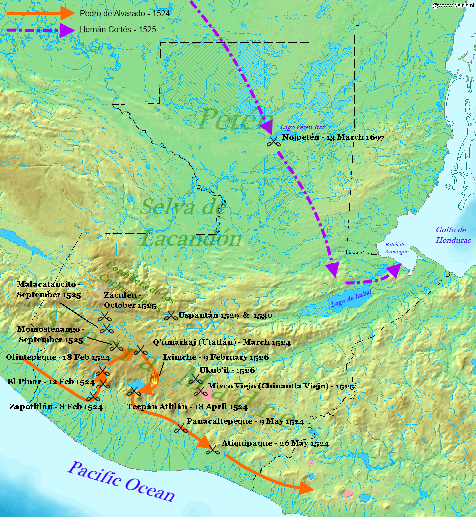
English: Map displaying the principal events of the Spanish Conquest of Guatemala, and the route taken by Pedro de Alvarado. Bounding box West -92.5°, South 13.5°, East -88°, North 18.2°. Center at 15°51′00″N 90°15′00″W / 15.85000°N 90.25000°W. |
| تاریخ | (UTC) |
| ماخذ |
Own work using: |
| مصنف |
|
| This is a retouched picture, which means that it has been digitally altered from its original version. Modifications: Added battles of the Spanish conquest and geographical locations. The original can be viewed here: Map of Guatemala Demis.png:
|
اس ملف کا لائسنس Creative Commons Attribution-Share Alike 3.0 Unported کے تحط ہے۔
- آپ آزاد ہیں:
- شیئر کرنے – کام کو نقل، تقسیم یا منتقل کرنے کے لیے
- ریمکس کے لیے – کام منبطق کرنے کے لیے
- مندرجہ ذیل شرائط کے تحت:
- انتساب – آپ کو اس کام کا انتساب مصنف یا اجازت دہندہ کے بتائے گئے طریقہ کے مطابق دینا ہوگا (تاہم یہ انتساب اس طرح نہیں ہونا چاہیے کہ اسے دیکھ کر ایسا محسوس ہو کہ اصل مصنف یا اجازت دہندہ آپ کے یا آپ کے ذریعہ اس کام کے استعمال کرنے کے حامی ہیں)۔
- یکساں شراکت – اگر آپ اس کام میں کوئی تبدیلی یا ترمیم کرتے ہیں یا اس کام پر مبنی کچھ نیا بناتے ہیں تو اسے بھی آپ اسی یا اس جیسے کسی اجازت نامے کے تحت شائع کر سکتے ہیں۔
اولین اپلوڈ کا نوشتہ
This image is a derivative work of the following images:
- File:Map_of_Guatemala_Demis.png licensed with PD-Demis
- 2006-12-20T22:49:24Z Mats Halldin 960x1042 (507761 Bytes) Map of [[Guatemala]] Bounding box West -92.5°, South 13.5°, East -88°, North 18.2°. Center at {{coor d|15.85000|N|90.25000|W|scale:2819999}}. {{demis-pd}} [[category:maps of Guatemala]]
Uploaded with derivativeFX
فائل کا تاریخچہ
کسی خاص وقت یا تاریخ میں یہ فائل کیسی نظر آتی تھی، اسے دیکھنے کے لیے اس وقت/تاریخ پر کلک کریں۔
| تاریخ/وقت | تھمب نیل | ابعاد | صارف | تبصرہ | |
|---|---|---|---|---|---|
| رائج الوقت | 22:34، 28 جنوری 2012ء | | 960 × 1,042 (677 کلوبائٹ) | Simon Burchell | +battles of Momostenango and Malacatancito, move other text make easier to read |
| 20:47، 28 جنوری 2012ء |  | 960 × 1,042 (677 کلوبائٹ) | Simon Burchell | +battles of Uspantán | |
| 22:11، 5 اکتوبر 2011ء |  | 960 × 1,042 (676 کلوبائٹ) | Simon Burchell | Added route of Hernán Cortés 1525 | |
| 21:25، 5 اکتوبر 2011ء |  | 960 × 1,042 (669 کلوبائٹ) | Simon Burchell | {{Information |Description=Map of Guatemala Bounding box West -92.5°, South 13.5°, East -88°, North 18.2°. Center at |Source=*File:Map_of_Guatemala_Demis.png |Date=2011-10-05 21:18 (UTC) |Author=*File:Map_of_Guatemala_Demis.png: Demis |
روابط
درج ذیل صفحہ اس فائل کو استعمال کر رہا ہے:
فائل کا عالمی استعمال
مندرجہ ذیل ویکیوں میں یہ فائل زیر استعمال ہے:
- ar.wikipedia.org پر استعمال
- ca.wikipedia.org پر استعمال
- en.wikipedia.org پر استعمال
- es.wikipedia.org پر استعمال
- fr.wikipedia.org پر استعمال
- hu.wikipedia.org پر استعمال
- it.wikipedia.org پر استعمال
- pnb.wikipedia.org پر استعمال
- uk.wikipedia.org پر استعمال
- vi.wikipedia.org پر استعمال