فائل:World empires and colonies around World War I.png
اس نمائش کا حجم: 800 × 323 پکسلز۔ دیگر تصمیمات: 320 × 129 پکسلز | 640 × 258 پکسلز | 1,554 × 627 پکسلز۔
اصل فائل (1,554 × 627 پکسل، فائل کا حجم: 63 کلوبائٹ، MIME قسم: image/png)
خلاصہ
| تفصیل |
English:
|
| تاریخ | 2 اگست 2007 (original upload date) |
| ماخذ | Taken from wikipedia map |
| مصنف | ذیل میں دیکھیں۔ |
| دوسرے نسخے |
.png)

|
This historical map image could be re-created using vector graphics as an SVG file. This has several advantages; see Commons:Media for cleanup for more information. If an SVG form of this image is available, please upload it and afterwards replace this template with
{{vector version available|new image name}}.
It is recommended to name the SVG file “World empires and colonies around World War I.svg”—then the template Vector version available (or Vva) does not need the new image name parameter. |
اجازہ کاری
اس تخلیقی کام کے حقوق کا مالک Ishvara7 at انگریزی ویکیپیڈیا اسے مندرجہ ذیل اجازت ناموں کے تحت شائع کرتا ہے:

|
آپ کو آزاد سافٹ ویئر فاؤنڈیشن کی جانب سے شائع کردہ جی این یو آزاد مسوداتی اجازت نامہ کی شرائط استعمال کے تحت اس دستاویز کو نقل، تقسیم اور/ یا ترمیم کرنے کی اجازت دی جاتی ہے۔ اس اجازت نامہ کی ایک نقل 'جی این یو آزاد مسوداتی اجازت نامہ کے عنوان سے میسر ہے۔ |
| اس ملف کا لائسنس Creative Commons Attribution-Share Alike 3.0 Unported کے تحط ہے۔ | ||
| لگاؤ: Ishvara7 at انگریزی ویکیپیڈیا | ||
| ||
| This licensing tag was added to this file as part of the GFDL licensing update. |
This file is licensed under the Creative Commons Attribution-Share Alike 2.5 Generic, 2.0 Generic and 1.0 Generic license.
لگاؤ: Ishvara7 at انگریزی ویکیپیڈیا
- آپ آزاد ہیں:
- شیئر کرنے – کام کو نقل، تقسیم یا منتقل کرنے کے لیے
- ریمکس کے لیے – کام منبطق کرنے کے لیے
- مندرجہ ذیل شرائط کے تحت:
- انتساب – آپ کو اس کام کا انتساب مصنف یا اجازت دہندہ کے بتائے گئے طریقہ کے مطابق دینا ہوگا (تاہم یہ انتساب اس طرح نہیں ہونا چاہیے کہ اسے دیکھ کر ایسا محسوس ہو کہ اصل مصنف یا اجازت دہندہ آپ کے یا آپ کے ذریعہ اس کام کے استعمال کرنے کے حامی ہیں)۔
- یکساں شراکت – اگر آپ اس کام میں کوئی تبدیلی یا ترمیم کرتے ہیں یا اس کام پر مبنی کچھ نیا بناتے ہیں تو اسے بھی آپ اسی یا اس جیسے کسی اجازت نامے کے تحت شائع کر سکتے ہیں۔
آپ حسب منشا اجازت نامہ منتخب کر سکتے ہیں۔
اولین اپلوڈ کا نوشتہ
Transferred from en.wikipedia to Commons by M0rphzone.
فائل کی تفصیلات کا اصل صفحہ یہاں تھا۔ درج ذیل تمام صارفین en.wikipedia کے ہیں۔
- 2008-08-17 11:30 Scooter20 1554×627× (72711 bytes) + Added Romania
- 2007-09-09 06:32 Swedish fusilier 1554×627× (72758 bytes) *Original Author: [[Ishvara7]], edited by [[Swedish fusilier]] to correct the colouring of several southern Indian Ocean islands (eg. [[Kerguelen]]) which should be coloured as French possesions. *Taken from Wikipedia map *Nations involved with imperialis
- 2007-08-11 12:48 Taktser 1554×627× (72824 bytes)
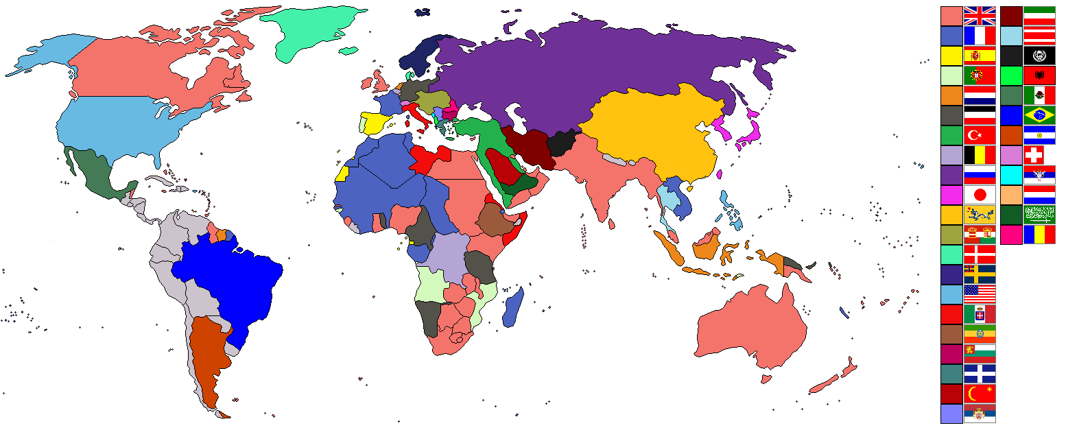
- 2007-08-02 22:04 Ishvara7 1554×627× (73211 bytes) *Ishvara7 *Taken from wikipedia map *Dated around 1900 *Nations involved with imperialism, directly or indirectly, are colored. Meant to potray the world around the time of WWI. *In case anyone wonders, the red flag with the yellow crescent and star is th
فائل کی تفصیلات کا اصل صفحہ یہاں تھا۔ درج ذیل تمام صارفین en.wikipedia کے ہیں۔
- 2007-08-02 21:15 Ishvara7 1554×627× (72719 bytes) *Ishvara7 *Taken from wikipedia map *Not all nations are colored. Only ones with the most importance related to colonialism, interaction with colonial powers, and WWI. *Map dates to the year 1900.
فائل کی تفصیلات کا اصل صفحہ یہاں تھا۔ درج ذیل تمام صارفین en.wikipedia کے ہیں۔
- 2007-08-02 19:27 Ishvara7 1554×627× (72762 bytes) *Ishvara7 *New nations labled according to importance within world politics and WWI. *Taken from old colonialism wikipedia map
فائل کی تفصیلات کا اصل صفحہ یہاں تھا۔ درج ذیل تمام صارفین en.wikipedia کے ہیں۔
- 2007-08-01 01:36 Ishvara7 1458×627× (63275 bytes) *Ishvara7 *Taken from old colonial map on wikipeia and outlined *Better images of flags and includes Ethiopian Empire *yes, it did take forever
فائل کا تاریخچہ
کسی خاص وقت یا تاریخ میں یہ فائل کیسی نظر آتی تھی، اسے دیکھنے کے لیے اس وقت/تاریخ پر کلک کریں۔
| تاریخ/وقت | تھمب نیل | ابعاد | صارف | تبصرہ | |
|---|---|---|---|---|---|
| رائج الوقت | 09:09، 8 نومبر 2021ء | 1,554 × 627 (63 کلوبائٹ) | Randomastwritter | ogaden | |
| 02:48، 5 دسمبر 2012ء | 1,554 × 627 (37 کلوبائٹ) | OjdvQ9fNJWl | Uploaded optimized image of first version here at Commons (latest on Wikipedia). File desc for prev version: *Ishvara7 *Taken from wikipedia map *Not all nations are colored. Only ones with the most importance related to colonialism, interaction with c... | ||
| 02:42، 5 دسمبر 2012ء | 1,554 × 627 (71 کلوبائٹ) | OjdvQ9fNJWl | Old version from Wikipedia (File:Imperialism.png) dated 21:15, 2 August 2007 by Ishvara7. File desc for prev: *New nations labled according to importance within world politics and WWI. *Taken from old colonialism wikipedia map. | ||
| 02:29، 5 دسمبر 2012ء | 1,554 × 627 (71 کلوبائٹ) | OjdvQ9fNJWl | Old version (File:Imperialism6.png) from Wikipedia by Ishvara7 at 19:27, 2 August 2007. File desc for prev upload: *Taken from old colonial map on wikipeia and outlined *Better images of flags and includes Ethiopian Empire *yes, it did take forever. Fi... | ||
| 02:25، 5 دسمبر 2012ء |  | 1,458 × 627 (62 کلوبائٹ) | OjdvQ9fNJWl | Uploaded old image version from http://en.wikipedia.org/wiki/File:Imperialism_5.png uploaded by Ishvara7 at 01:36, 1 August 2007 (UTC) | |
| 02:03، 5 دسمبر 2012ء | 1,554 × 627 (71 کلوبائٹ) | OjdvQ9fNJWl | {{Information |Description={{en|*Taken from wikipedia map. *Dated around 1900 (shows Italian - although the flag is not correct - North Africa post 1910 and Austro-Hungarian Empire circa WW1). British territories o... |
روابط
درج ذیل صفحہ اس فائل کو استعمال کر رہا ہے:
فائل کا عالمی استعمال
مندرجہ ذیل ویکیوں میں یہ فائل زیر استعمال ہے:
- ar.wikipedia.org پر استعمال
- bs.wikipedia.org پر استعمال
- ckb.wikipedia.org پر استعمال
- en.wikipedia.org پر استعمال
- fr.wikipedia.org پر استعمال
- km.wikipedia.org پر استعمال
- pnb.wikipedia.org پر استعمال