ٹیبل ماؤنٹین
| ٹیبل ماؤنٹین Table Mountain | |
|---|---|
 | |
| بلند ترین مقام | |
| بلندی | 1,084.6 میٹر (3,558 فٹ) |
| امتیاز | 1,055 میٹر (3,461 فٹ) |
| فہرست پہاڑ | جنوبی افریقہ کے پہاڑوں کی فہرست |
| جغرافیہ | |
 | |
| ارضیات | |
| قسم پہاڑ | ریتیلا پتھر |
| کوہ پیمائی | |
| پہلی بار | انٹونیو دی سلدانا، 1503 |
| آسان تر راستہ | Platteklip Gorge |


ایوانِ عکس
ترمیم-
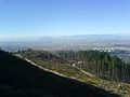
 سگنل پہاڑی سے ایک منظر
 -
 پہاڑ کے اوپر کیبل کار اسٹیشن
 -
 کیبل کار
 -
 کیپ ٹاؤن, Signal Hill, Table Bay and Robben Island as seen from the upper cable station of the Table Mountain Cableway.
 -
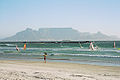 بلوبرگ اسٹرینڈ سے ٹیبل ماؤنٹین اور کیپ ٹاؤن کا منظر
 -
 The concrete part of the Bridle Path—the most gradually-inclined route to the Back Table
 -
 ٹیبل ماؤنٹین اور کیپ ٹاؤن ساحل
 -
 پہاٹی کیبل اسٹیشن کا منظر
 -
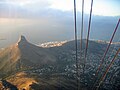 کیبل کار سے لئنس ہیڈ کا منظر
 -
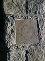 Time is a Gift, one of several plaques at the top of Table Mountain
 -
 The Table Cloth draped over the north facing slopes
 -
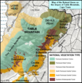 Map showing the conservation areas and forests of the Eastern Slopes. e.g. Newlands Forest, Cecilia Park, Kirstenbosch.
 -
 View of Table Mountain from Blouberg beach.
 -
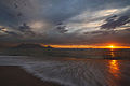 View of Table Mountain at sunset.
 -
 As seen from the other side of Table Bay at sunset.


حوالہ جات
ترمیم- ↑ لوا خطا ماڈیول:Citation/CS1 میں 4492 سطر پر: attempt to index field 'url_skip' (a nil value)۔
| ویکی ذخائر پر ٹیبل ماؤنٹین سے متعلق سمعی و بصری مواد ملاحظہ کریں۔ |