جزیرہ ایسٹر
جزیرہ ایسٹر (easter island) (ہسپانوی: Isla de Pascua) جنوب مشرقی بحر اوقیانوس میں ایک پولینیشی جزیرہ ہے۔
جزیرہ ایسٹر Rapa Nui Isla de Pascua | |
|---|---|
 | |
 | |
| دار الحکومت | ہانگا روا |
| سرکاری زبانیں | None. Spanish and راپا نوی زبان widely used. |
| نسلی گروہ (2002) | Rapanui 60%, European or mestizo 39%, Amerindian 1% |
| آبادی کا نام | جزیرہ ایسٹر or Pascuense |
| حکومت | Special territory of Chile[1] |
• Provincial Governor | Carmen Cardinali Paoa |
• ناظم شہر | جزیرہ ایسٹر |
| الحاق to چلی | |
• Treaty signed | September 9, 1888 |
| رقبہ | |
• کل | 163.6 کلومیٹر2 (63.2 مربع میل) |
| آبادی | |
• 2012 مردم شماری | 5,806[2] |
• کثافت | 35/کلو میٹر2 (90.6/مربع میل) |
| کرنسی | Peso (CLP) |
| منطقۂ وقت | یو ٹی سی−6 (EAST) |
• گرمائی (ڈی ایس ٹی) | یو ٹی سی−5 (EASST) |
| کالنگ کوڈ | +56 32 |
| انٹرنیٹ ایل ٹی ڈی | .cl |

Easter Island
Location of Easter Island in the Pacific Ocean
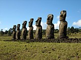
تصاویر
ترمیم- Moais
-

-

-


بیرونی روابط
ترمیمحوالہ جات
ترمیم- ↑ Pending the enactment of a special charter, the island will continue to be governed as a province of the Valparaíso Region.
- ↑ {{cite web|url=http://www.censo.cl/2012/08/resultados_preliminares_censo_2012.pdf%7Ctitle=Resultados[مردہ ربط] Preliminares Censo de Población y Vivienda 2012|publisher=Instituto Nacional de Estadísticas|date=31 August 2012|language=Spanish
| ویکی ذخائر پر جزیرہ ایسٹر سے متعلق سمعی و بصری مواد ملاحظہ کریں۔ |