کنگسٹن اپون ہل
کنگسٹن اپون ہل (انگریزی: Kingston upon Hull) برطانیہ کا ایک رہائشی علاقہ جو انگلستان میں واقع ہے۔[2]
| City and Unitary authority | |
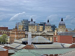
 Hull skyline from Princes Quay car park | |
| عرفیت: Hull | |
 Hull shown within the East Riding of Yorkshire | |
| Sovereign state | United Kingdom |
| آئین ساز ملک | England |
| علاقہ | یارکشائر اور ہمبر |
| Ceremonial county | East Riding of Yorkshire |
| قیام | 12th century |
| City Status | 1897 |
| Administrative HQ | Guildhall |
| حکومت | |
| • قسم | Unitary authority, City |
| • Governing body | Hull City Council |
| • Leadership: | Leader & Cabinet |
| • Executive: | لیبر |
| • MPs: | Alan Johnson (L) Diana Johnson (L) Karl Turner (L) |
| رقبہ | |
| • شہر | 71.45 کلومیٹر2 (27.59 میل مربع) |
| آبادی (mid-2018 تخمینہ.) | |
| • شہر | 256,100 (Ranked 51 واں) |
| • کثافت | 3,486/کلومیٹر2 (9,030/میل مربع) |
| • شہری | 573,300 (LUZ) |
| • Ethnicity (2005 Estimate)[1] | 92.4% White 3.81% S. Asian 1.45% Black 1.26% Mixed Race 0.95% Chinese and other |
| منطقۂ وقت | گرینچ معیاری وقت (UTC+0) |
| مملکت متحدہ میں ڈاک رموز | HU |
| ٹیلی فون کوڈ | (01482) |
| آیزو 3166-2:GB | GB-KHL |
| ONS code | 00FA (ONS) E06000010 (GSS) |
| NUTS 3 | UKE11 |
| ویب سائٹ | www.hullcc.gov.uk |
تفصیلات
ترمیمکنگسٹن اپون ہل کا رقبہ 71.45 مربع کیلومیٹر ہے، ہے۔ کی مجموعی آبادی
مزید دیکھیے
ترمیمحوالہ جات
ترمیم- ↑ "Resident Population Estimates by Ethnic Group (Percentages); Mid-2005 Population Estimates"۔ National Statistics Online۔ Office for National Statistics۔ 2019-01-07 کو اصل سے آرکائیو کیا گیا۔ اخذ شدہ بتاریخ 2008-03-27
- ↑ انگریزی ویکیپیڈیا کے مشارکین۔ "Kingston upon Hull"
|
|
